2020-12-13 42 -79
| Sun 13 Dec 2020 in 42,-79: 42.3731049, -79.4947041 geohashing.info google osm bing/os kml crox |
Contents
[hide]Location
Next to Railroad Tracks, Southwest of Fredonia
Participants
Expedition
With not a lot going on this weekend (and forecasted bad weather), I mentioned to my girlfriend that I might drive down to the Dunkirk Graticule for an expedition on Sunday and she said it sounded like fun and was willing to tag along.
We had a lazy morning, and lounged around for a bit after breakfast, but decided on our course of action. If we got to Fredonia around lunchtime, we could order something down that way before continuing on to the hash. Also, there was a close Geocache which sounded really interesting and hoped to turn this into a Hash Collision (Honorable Mention) event. Since this would be right next to a very active (according to the Cache page) Railroad track, and with the rain threatening, I decided to leave the dogs at home. We would have to be especially careful around the tracks, but I figured we could park in between the two sets of tracks off the dead end road near the hash.
The plan went very well, and we ordered subs from a deli shop near 'downtown' Fredonia. Since we ordered as we were driving into town, we had some time to walk around for a bit before getting our subs. We were happy to see the rain was holding off so far, but because it was still pretty chilly, we ate in the car next to a town park. Satiated, we continued our drive to the hash with no issues. Driving down the dead end road toward the hash and the tracks, we got to the top of a hill that led down to the tracks, but we decided to respect the Dead-End, Do Not Enter Road signs. There was a spot to pull off the road anyway so we weren't blocking anything and walked the rest of the way.
Our first stop was the hash and I was surprised to find it on the outside of the tracks. I thought I remembered seeing it in between the first set of tracks, but my GPS disagreed. I was able to zero in on the hash without much of a GPS dance and got a couple pictures with J keeping an eye out for any approaching trains. I then got a reading for the distance to the Cache for the Hash Collision event before heading down the tracks that way.
The Cache page says this was set up near a spring for an old Coal and Water refill station for the Trains when they still ran on Steam power. The structure that held the coal was removed and there isn't much left of the foundation, but the cache was near the spring, in the woods a bit away from the tracks. We wandered down the tracks first to see if we could see the ruins, but wasn't sure what we were looking at. Noting we were past the cache coordinates, we followed the advice of the Cache page and went back a bit before cutting into the woods to avoid the swampy area. Getting to the Cache location, we had some trouble finding the cache, but checking out the cache page again, we were able to locate the distinctive tree. However, J discovered why this cache definitely should NEVER be done at night. As she was stepping across one of the stream channels, she stepped in thinking she might sink a little but would be easier to step across. She ended up sinking well past her boots and nearly halfway up her calf! Working our way around the tree after shaking off as much of the mud as possible, we were able to find the cache.
We didv forget to bring a pen to sign the log, but our pictures should serve as proof that we found the cache and it was within range for a Hash Collision Honorable Mention. We then carefully made our way back to the car. Getting back to the tracks, we did see a short train go by as we came out of the woods so we just paused and watched it go safely by.
On the way back, J really wanted to take me on one of the Summer Challenge Hikes at Zoar Valley that she liked, but I tend to avoid that area as there are drop-off cliffs and generally too dangerous to take the dogs. Without them, it was a great opportunity and not much of a detour to stop for a short but nice hike on the way home.
Since this was near the town of Portland (technically West Portland, I think), I thought I might be able to complete a Tale of Two Challenge, but it looks like there wasn't one available. It looks like this is a popular location as there have already been a couple Portland Challenges completed so I'll add another one, this time from New York.
Additionally, this is the first expedition in a short Consecutive chain, with the next day's hash in Allegany State Park linked here.
Photos
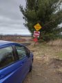
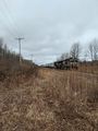
Although I took this as we were leaving, A view of where we parked. The hash is down the hill and to the right.
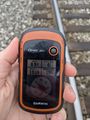
Spot on!
Accuracy.

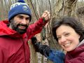
Standard Stupid Grins at the hash. Sorry for the crack in the screen messing up the picture...
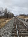
View East from the hash.
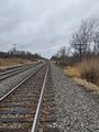
View West toward where we walked from.
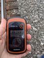
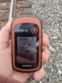
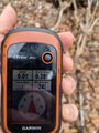
For proof of Hash Collision event, the distance to the Cache from the Hash.
Took a while, but we were able to find it. My girlfriend sank halfway to her knee in mud at one point, demonstrating why this cache should NOT be done at night or when there is snow/ice around...
For consistency, distance from the Cache, back to the Hash.
After putting the Cache back in it's hiding place, we got to watch a short train go by as we got back to the tracks.
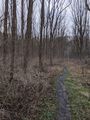
A view of the hiking trail afterwards in Zoar Valley.


Ribbons
This user earned the Land geohash achievement
|
Pedalpusher & J earned the Hash collision honorable mention
|
Pedalpusher & J issued a challenge for the Tale of Two Hashes achievement
|
Pedalpusher earned the Drag-along achievement
|