2020-12-14 42 -78
| Mon 14 Dec 2020 in 42,-78: 42.0934120, -78.8246746 geohashing.info google osm bing/os kml crox |
Location
Allegany State Park near I-86 on the Quaker side
Participants
- Pedalpusher
- Simon the dog
- Myka the dog
Expedition
With a bunch of time off that I didn't take earlier in the year for a planned trip to Australia (cancelled due to the Pandemic), I had a couple extra days I needed to use. Fortunately, I had taken off until Wednesday this week so I was available for an unplanned adventure to ASP during the day. Had I been working, this likely would not have been possible, as I wouldn't have daylight left after getting done with work.
After a lazy morning, I saw the hashpoint looked to be accessible near ASP and according to Google Maps, just inside the Park Boundary. There was a High Power Line running nearby with a trail along it to get close. This looked like a very interesting place and I made plans to go after lunch.
With a daypack filled with snacks and extra clothes, and the dogs in the car, we were on our way around 13:00. The drive down wasn't too bad until just before getting to Salamanca where I got stuck behind a plow that was moving ridiculously slow. The speed limit was 55 MPH and he was going about 40 and spreading salt. But when he got to the city limits and the speed dropped to 30, he decided to go 20. So this guy was purposely going REALLY slow. It was extremely frustrating especially since I had no way to pass. Then it got worse as he continued to make the same turns I did and eventually got on the thruway. It felt freeing to FINALLY get around the plow and of course it wasn't until this point that he pulled over to let everyone by. Wow, it took some time for me to come back to my normally calm self, but I was mostly back in the right mindset as I found the dirt road leading up to the Power Lines.
Getting the dogs out, I experienced a bit more frustration as I first forgot to lock the car, then had to go back again because I forgot my phone which I was using for navigating. That really would have sucked if I got all the way down the trail before realizing I wouldn't be able to take any pictures. Anyway, we were finally on our way and the walk under the Power Lines was mostly easy although I did have to keep the dogs away from some garbage and animal carcases that people had dumped toward the beginning.
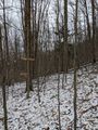
With the path starting to head down into a small valley, I decided it was time to cut into the woods toward the hash. I didn't think it would be wise to walk all the way down, just to have to climb back up that elevation toward the hash. Especially since we still had further up to go. It was steeper that I expected, but it was manageable. Following my GPS, I started to move in a wider switchback style to make it easier on the steeper sections. I was starting to sweat a bit and had to stop a couple times to catch my breath, but was closing in before long.
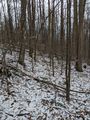
Finding the hash area, I started the GPS dance and was able to get a good reading after a fair amount of wandering around. With pictures taken, I decided I needed to get to find the highest elevation as we weren't far away from the top of the hill. I think we just had to go a couple hundred meters before cresting, but at the top was really windy. We didn't stay long before heading back and kind of veering to the right a bit. I wanted to hit the other side of the creek that made the earlier valley. I figured if I could keep some elevation, I would come out of the woods about halfway up the other side and wouldn't have to climb as much to see what was over there.
Getting to a second tributary to the main creek, I looked ahead and saw a bunch of deer running away from us. There were at least 4 and possibly 5, but were far enough away that the dogs didn't see them. We continued on our way and it was getting to the point where I was starting to think I may not be on the right track and maybe going the wrong way somehow? I was getting ready to pull out my phone to check our position, when just through the trees I could make out the wires and a tower. Whew. Everything worked out as planned!
Back on the trail under the wires, we headed up the rest of the way. Like before, getting to the top was very windy but this time, there were no trees to block the wind and it just started to snow lightly. I couldn't quite see what was on the other side, so we continued to walk on the flat bit at the top until we were looking down on I-86 and I recognized the view. This was the hill we could see from the road where the Wires dropped down and went along the road for a while. Next time I'm driving to the Quaker side of ASP, I'll be able to look up and say "I was there"!
Satisfied, we turned around and made our way back to the car. At this point, it looked like Myka was getting a bit tired and cold, but once we got down into that valley, we were much more protected from the wind at least. Up the other side of the valley and getting to where we initially made our way into the woods, it got mostly flat as well so it was an easier and uneventful walk the rest of the way to the car and drive home.
As it was, this is a Consecutive Expedition, linking to the previous Expedition here. There was no accessible or close geohash for 2020-12-15 so the streak ends here at two.
This is also a candidate for a Last Man Standing, but we'll leave it a while longer, just in case...Months later, it still is so this gets a ribbon!
Photos
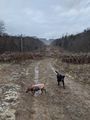
Walking down the path under the wires. We eventually made it to the top of the rise way off in the distance.
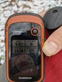
Spot on at the hash!
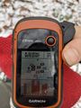
Accuracy.
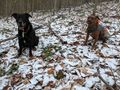
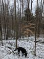
Hash-Dogs at the Hash.
Relooking at the map, this view is toward the North (not east that I originally put in the filename).
Making this view to the South.

Standard Stupid Grin at the hash.
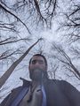
When I went to change to the Selfie mode, I was holding the phone low and thought this was an interesting picture of the tree tops at the hash.
Heading back toward the wires, we found the area where the creek started and made a big ravine that we wanted to be on the right side of walking back.
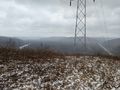
Getting back to the wires and to the top of the hill, we could overlook Rt 219 and the Allegany River. Salamanca is behind the hills across the valley and is not visible from here.
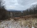
Heading back down the hill, a view toward the West and down into the valley we skipped going and coming back from the hash.


Ribbons
This user earned the Land geohash achievement
|
Pedalpusher earned the Consecutive geohash achievement
|
Pedalpusher earned the Last Man standing achievement
|
Expeditions and Plans
| 2020-12-14 | ||
|---|---|---|
| Buffalo, New York | Pedalpusher, Simon the dog, Myka the dog | Allegany State Park near I-86 on the Quaker side |