2021-01-23 42 -78
| Sat 23 Jan 2021 in 42,-78: 42.6565403, -78.9717943 geohashing.info google osm bing/os kml crox |
Contents
[hide]Location
In the Woods off Versailles Plank Road in Angola
Participants
Plans
Since it's Saturday, I'll be aiming for an Official Saturday Meetup. However, looking at the Streetviews, there really isn't any place to pull over and park. This is within bike riding distance, but it'll be a pretty cold one. The high is supposed to be 22° F (-6° C) for a Frozen Expedition. My girlfriend is planning on coming over in the morning and we will take Simon the Dog out for a snowshoe hike (Myka the Dog will be bogged down by all the snow and just too cold so we'll leave her home). I figure as long as we are back by 14:30, I should have plenty of time for a slow, careful bike ride over to the hash area. There aren't any posted signs in the streetview from 2019 so I'm hoping it'll be clear. I will need to be extra careful though as the snow might be a bit deep walking through the woods on the last section to the hash. It'll definitely be an adventure!
Expedition
Turns out the snow was the least of my problems...
J came over and we loaded up Simon in the car and we headed over to the Hunter's Creek area for another on the list of the Winter Hiking Challenge. The snow wasn't bad, but as we pulled in, we found someone stuck in the driveway when they tried to go around a massive pothole. They tried waiving us around, but we stopped to help get them out. I had a shovel in the back and used that to help dig them out. With a couple of us pushing, we were able to get them moving again. Getting to the parking area, we found it was nearly full. This Hiking Challenge has really taken off and all the hikes on the list have been busy. I think we have almost 2,000 hikers at this point. With all these people hiking, we really had no need for the snowshoes at all since the path was pretty packed down.
Once we got on the trail, we really didn't run into many people, as there are multiple trails. Getting to the landmark, we got our pictures and had a snack before heading back. We got back to the house a bit before 14:00, but because I wanted to relax for a while and then needed to get ready to ride, I ended up leaving for the Hash close to 15:15. Heading West out of Hamburg, I contended with a decently strong headwind until I got to Route 20 and headed South. The hash-road was further than I remembered but I finally made it and found no Posted Signs on the woods near the hash. Jumping the ditch with my bike, I rested it against a small tree and navigated around the thorny shrubs and eventually closed in on the Hash.
About 15 minutes after 16:00, I was able to get a good reading and close enough for me to call it an Official Saturday Meetup! I got a few pictures of the area before heading for home. My initial plan was to continue down Versaille Plank road into Eden and come back on Route 62. However, that would be an extra mile or so plus I would still be contending with a side/head wind. I decided instead to retrace my route to get there and would then be helped home once I turned back onto Lakeview going back into town.
With the pandemic going on this year, I kind of put cycling to the side and focused more on hiking so I'm not really in riding shape, and by the time I got to that turn, I felt like I was dying. My legs were getting numb from the effort, my toes from the cold, and I could feel my energy draining. I knew I just needed to keep pushing and would eventually make it, but I was definitely playing the 'just get to the next landmark' game to motivate myself. Turning onto my street, was a great relief and I knew I just had a couple blocks left before I could collapse on my living room floor.
Once I put my bike away, I fed the dogs and then just laid down on the floor for about 30 min, feet in front of the heater to warm up. Once I started feeling better, I ate some leftovers, and heated up some soup for dinner.
As mentioned on the Discussion page, I'm issuing a Challenge for 'Versailles'.
Photos
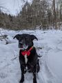
Simon posing earlier at the Challenge Landmark at Hunter's Creek
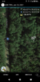
Getting to the Hash area, I took a screenshot for the Versailles ToTH Challenge.
Took a little time, but I made it!
The view East (away from the road).
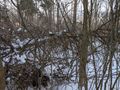
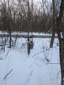
View West (toward the road).

Standard Stupid Grin at the hash.
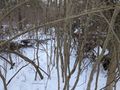
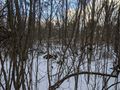
Walking back toward the road, a quick picture of the hash.
Hashbike is still right where I left it.

Proof for the Frozen hash.


Ribbons
This user earned the Land geohash achievement
|
Pedalpusher earned the Bicycle geohash achievement
|
Pedalpusher issued a challenge for the Tale of Two Hashes achievement
|
Pedalpusher earned the Frozen Geohash Achievement
|
Pedalpusher earned the xkcd Viginturion achievement
|