2021-08-10 47 8
| Tue 10 Aug 2021 in 47,8: 47.2539957, 8.9484850 geohashing.info google osm bing/os kml crox |
Location
In a small forest near Goldingen.
Participants
Plans
Take the afternoon of and ride a bus as close as possible and then hike up to the hash.
Expedition
I diviated from the plan right at the start: There was a interesting GeoCache one bus stop further and so I did not leave the bus at the closest station. It was a boring cache after all but at least I found it.
Back to where I initially planed to start, I found a landslide blocking my nice hiking route. But I found an other way which was also not bad. So I had a nice little hike and reached the hash with out further trouble at 17:24. It was inside a boring forest but just before it, it offered a nice view.
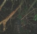
To continue to some more caches, I checked the map. It told my to backtrack and take a long detour. I figured that it would be quicker any way than climbing up though the thick and steep forest. I also heard some cowbells right at the edge of the forest which bearers might block my way. So of course I took that path throug the forest. Luckily the forest cleared soon, the cows where a bit away behind a fench and a way on fresh cut grass stretched before me... Perfect!
For the end of the day, I hiked up to a very nice viewpoint and enjoyed the sun and a apple cider.
Photos
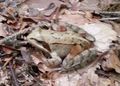
Hashfrog
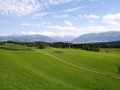
View a few meters away from the hash
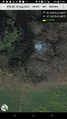
Hashshot
Here I claim it is
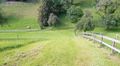
Cows and tricky path...
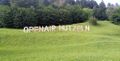
Advertising on the way
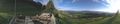
Final View


Achievements
Tungmar earned the Two to the N achievement
|