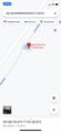
2021-09-01 48 7
| Wed 1 Sep 2021 in 48,7: 48.4435937, 7.5916255 geohashing.info google osm bing/os kml crox |
Location
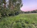
In a hedge between a field and a brook, near Schaeffersheim.
Participants
Plans
Today’s coordinates are very close to yesterday’s geohash. The plan is the same: take the train to Erstein, cycle to and from the coordinates, and take the train back home.
Hopefully Baarde won’t repeat yesterday’s mistakes.
Expedition
I took the train from Sélestat to Erstein, then cycled for 10 minutes on the D426 road through Schaeffersheim, up to a bridge on a small brook that marks the village western boundary.
The sun was setting over the distant mountains and the sky was full of colours. It was very pleasant.
I left my bicycle near the road and sneaked between a thick hedge and a cornfield. Fortunately, the cornstalks were widely spaced and I quickly reached a meadow. The coordinates were located in the hedge, between two nondescript trees.
I recorded proof while dozens of mosquitoes were attacking me. I took off, returned to the road and cycled back to the train station.
Photos
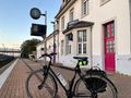
In Erstein
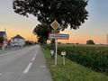
In Schaeffersheim
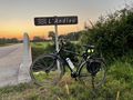
The end of the road
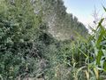
A cornfield, yeah!
The geohash
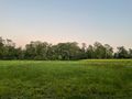
Coordinates reached
Surroundings (South-East)
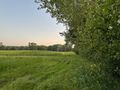
Surroundings (South)

Stupid grin


Achievements
Baarde earned the Land geohash achievement
|