2021-09-04 40 -4
| Sat 4 Sep 2021 in 40,-4: 40.3326847, -4.1209803 geohashing.info google osm bing/os kml crox |
Location
Near the road between Villamanta and Villamantilla (yet again), very close to Villamantilla.
Participants
Plans
Expedition
Autumn is slowly coming to central Spain, so it's getting a bit cooler. When I left home around 14:00, it was a comfortable 28°C.
The geohash was pretty close to my home base, just a ten minutes motorcycle ride. Otherwise, it turned out to be quite typical: a some hundred meters walk on a path, then some tens of meters into the wilds (and, yet again, thistles). Once more, I was impressed by the silence, only the sand crunching under my boots and a horse snorting in the distance.
Anyway, I was done with this geohash relatively quickly, but still in expedition mood, so I decided to tie up some loose ends.
In expedition 2021-07-26_40_-4, I had discovered a reservoir which I did not know before. I had taken a photo from far, but I could not reach it. In the meantime, I had researched ways to get there, but not consistently tried them.
There were two potential access points, one from the North and one from the South. I had found the northern one blocked by a closed barrier, so I tried the southern one this time, determined to get as close as possible to the reservoir. The last piece of the road was quite bad, bumpy with evil potholes, but just manageable with the heavy Goldwing. So I could finally park directly at the waters.
There were very few people around, but on the other hand, there were few locations where one could directly access the water, and even fewer with a bit of kind of a “mini beach”, and these were all occupied by small groups. So, even with few people, it was kind of crowded. Nevertheless, a very scenic place.
Tracklog
Photos

“Hunting grounds”, “forbidden to leave the path”; this may require creative interpretation.
Some hundred meters to walk.

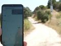
Here it is, 20 meters off the path.
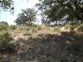
The stone near the bottom at the center marks the geohash. I'll walk up the hill in the back for some views.
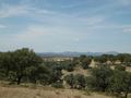
View from the top of the hill towards Villamantilla.
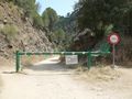
The blocked northern access to the reservoir I had seen from far during expedition 2021-07-26_40_-4.
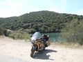
Finally having reached the reservoir via the southern access, parking directly at the waters.
Lots of water, few people.
The dam I crossed to get here.
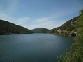
The reservoir is really large, I walked along from one end to the other.
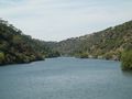
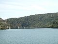
During expedition 2021-07-26_40_-4, I had only seen this small part of it with the marker buoys. I must have been somewhere up the hill to the right.
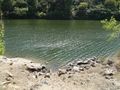
One of the few spots with direct access to the water.


