2021-09-10 39 -106
| Fri 10 Sep 2021 in 39,-106: 39.5046797, -106.1520766 geohashing.info google osm bing/os kml crox |
Contents
[hide]Location
Next to the Gore Range trail, across I-70 from Copper Mnt Ski resort
Participants
Expedition
Continuing our road trip on our way to Denver, you can find the previous expedition here.
This was quite a roller coaster of an expedition...Checking the coordinates for today, I found that this hash looked like it was right next to a trail that ran along I-70 and reviewing the satellite pictures, it appeared that we could park off the exit ramp and just walk down the trail about a mile to the hash. Should be a piece of cake. It would be a little tricky to get to the parking spot as we would have to drive past, get off at the next exit and come back to take the correct exit ramp on the other side.
We stopped at Casey Brewing Taproom in Glenwood Springs on our drive from Dinosaur Monument where we saw some dinosaur bones still in the rocks, petroglyphs and did a short hike in the morning. We hit some traffic on I-70 due to construction to fix what appeared to be flood and rock slide damage, but we were able to get through without too much delay. Near the hash, we navigated the exits and avoided accidentally getting off at the rest stop right before the exit. However, as I pulled off the exit to park for the hash, I realized there were No Parking signs all along the road here and I wasn't quite sure what to do. With no choice, we got back on the road and pulled off in town to figure out our next move. J was encouraging and hopeful we could still get there and we decided to try the loop again and pull off at the rest area and reassess at that point. It was getting a bit later in the day so we were running out of daylight and this would push us further back.
Pulling off, I parked at what looked like a trailhead and pulled things up again on the HashDroid app. We weren't too much further back and not quite a mile directly to the hash. I estimated we would have to walk about 1.5 miles and with an hour and a half before sunset, we should be good. J was still willing to try and we grabbed and extra layer and some lights before we started walking. Getting to that area where we were originally planning to park, it looked like rocks had been dumped in front of the trail to the road there and the signs were keeping people away. Likely, there were a couple accidents trying to get back on the exit ramp so they just wanted to prevent people from parking there.
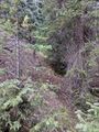
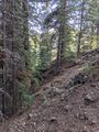
The views were fantastic as we walked around the mountain into the sun and it warmed up significantly on this side. The trail started to go uphill a bit, but it wasn't anything we couldn't handle. Getting into the clearing near the hash, I knew we had to start heading off the trail and a bit downhill. As I walked through the trees, I was pretty excited I was just a few steps away, and then my heart sank as I stepped up to a steep but shallow gully. I moved upstream and found a spot I would be able to navigate and was able to cross over to the hash. J didn't want to take a chance so she stayed on the other side and waited while I homed in on the hash. Getting my pictures, I was happy to add another Graticule to the list and start a Consecutive Hash!
After getting back to the car, we continued a short way down I-70 to Fresno where we stopped at another brewery (Outer Range) for Dinner before making it back to Denver to complete our trip. We were still spending the weekend and I saw there was one more chance for a Geohash north of the city the next day. You can read about tomorrow's expedition here.
Photos
Starting the day in Dinosaur Monument in Utah, we saw half-excavated dino bones that they left exposed in the rock so future visitors could see them as they were found.
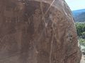
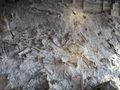
We also stopped at a couple petroglyph spots as well.
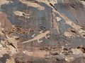
The Iconic Lizard that's in the brochure.
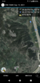
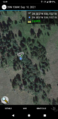
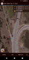
Getting to the hash area, a HashDroid screenshot of where we ended up parking to start our adventure.
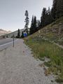
It's the Gore Range National Forest sign at the parking area, looking down the valley toward where we will need to walk.
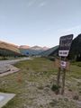
Getting to the area I initially wanted to park...
...there are now signs saying to use the 'Scenic Parking Area' instead.
Jumping to the hash, I made it!
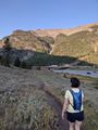
View East from the Hash, with J waiting on the other side of the gully for me.
View North from the hash and upstream (not that there was any water in the creek today).
View South, downstream and toward Copper Mtn Ski area.

Another Graticule in the books!
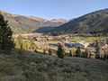
Getting out of the woods, a semi-panoramic view of the Ski Area and surrounding mountains.
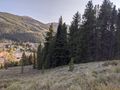
Pan part two with the hash woods on the right.
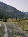
Walking back on the trail with the sun close to setting behind us.
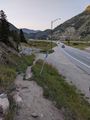
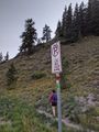
Getting back to the attempted parking area, you can see the pile of rocks they dumped to close off the area people used to park in.
You can see why I initially wanted to park here. Not only was it closer, but it looked like there was ample parking.
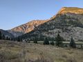
Turning the corner around the hash-mountain, the sun has set in the valley, but not on the mountains across I-70.
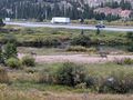
Almost back, we can see the hash-mobile and the parking area.
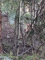
Near the ponds by the parking area, we saw a couple bucks keeping a close eye on us as we walked by.
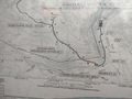
A picture of the trailmap at the trailhead. I edited in a red dot to show the location of the hash.


Ribbons
This user earned the Land geohash achievement
|
Pedalpusher earned the Consecutive geohash achievement
|