2021-10-19 -38 146
| Tue 19 Oct 2021 in -38,146: -38.0555502, 146.1121362 geohashing.info google osm bing/os kml crox |
Location
In bushland off the side of a four-wheel-drive track near the Latrobe River.
Participants
Expedition
On the morning of 19th October 2021, just before 8 o'clock, I sent a message to my boss letting him know I would be taking a sick day. He didn't ask for details, and of that I'm glad, as my symptoms were rather non-specific. But I had consulted the app, and whatever concocted malaise I had been stricken with could only be treated with a pilgrimage to the rather enticing coordinates.
Unlike most (or all) of my recent hashes, this would not be in open farmland. I would not be perched in the middle of some paddock with curious cattle looking on. Instead, this point lay in the middle of the Sweetwater Creek Nature Conservation Reserve, right on a marked track. It looked achievable and interesting.
It was both of these. After a fairly uneventful ride up the Old Sale Road I cut away from the farmland into the bush. It didn't take long for the track to deteriorate.
Rain had pooled on the clay surface, which itself had been stirred up by adventurous four-wheel-drivers. As I ventured down one gully I realised my folly as the clay immediately coated my tyres, and turned my wheels into a set of skis of which I had virtually no control. I slid sideways into the branches of a fallen tree, and decided to push on, for the moment, on foot.
I worked my way onwards, riding when I could, but often having to resort to pushing. My tyres became caked with mud, my brakes were virtually useless, my shoes would slip and slide all over the pedals. I would stop periodically to clear the mud from around my chain.
Eventually, I reached a crest, and before heading down what looked like a perilous muddy slope, checked the map. I was slap-bang on top of the point! I leaned my bike against a tree, took a few steps into the bush, and got to the precise coordinates.
I decided to push in the direction I was headed. The track would double back and eventually get me back on the main road, and I suspected the worst was behind me. I was correct, though one of the marked tracks was missing, so I was treated to a longer circuit than I expected, and although there were sections I would need to dismount, the track would not deteriorate to the same extent again.
Eventually finding my way back to Old Sale Road I was treated to the reward for the morning's climbing as I descended towards Darnum and Yarragon. But a headwind raised the spectre of a hard slog home, so I invited my partner to join me for lunch in Yarragon, and took advantage of her offer of a lift home afterwards.
Tracklog
Photos
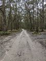
The track started well..
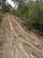
...but quickly deteroriated...
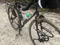
...coating my bike with mud.
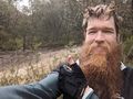
At the hash

Proof!


Achievements
Mdixon4 earned the Bicycle geohash achievement
|
Mdixon4 earned the One with Nature Geohash Achievement
|