2021-12-27 42 -78
| Mon 27 Dec 2021 in 42,-78: 42.5498387, -78.0603531 geohashing.info google osm bing/os kml crox |
Contents
[hide]Location
Northern area of the Art Rosco Ski area, Allegany State Park
Participants
- Pedalpusher
- Simon the dog
- Myka the dog
Expedition
NOTE: The indicated Map Coordinates on the page are wrong, but the marker is correct and geohashing.info shows this hashpoint
What a difference a day makes. Yesterday, the girlfriend and I hit up the southern side for a Geohash and today it landed in the Northern area of the Cross Country Ski area at Allegany. I needed to use up some days off at work before the end of the year so I don't lose them and just happened to already have today off. Not wanting to miss an adventure at Allegany, I decided to take the dogs and see if I could start another Consecutive hash streak.
After eating an early lunch, we were headed to Allegany a little before noon. There wasn't any snow around, but as we drove south, the higher elevations started to accumulate the snow just a little so it looked really nice with a dusting of snow. As we drove into Allegany, though, the snow started to get a bit deeper as we headed up the mountain to the top. Getting to the parking area, I estimated there was about 1-2 inches (3-5 CM) of snow on the ground. I was a little worried as the Ski area doesn't permit dogs, hiking or snowshoeing during ski season, but since there was just a small layer, I didn't think you could actually ski so we walked over to the trailhead. Seeing all the footprints made me feel better and I didn't worry about it and we continued on. If the snow was deeper, we would have found a different place to hike and skipped the Geohash.
About 2 minutes in, we did see two skiers coming out but they really didn't care and they said 'Hi' as they went by. They don't like hikers etc on the groomed ski trails because you 'post-hole' into the snow and ruin the ski tracks making it dangerous to catch a ski in a hole, especially if there was a thaw/freeze cycle and the snow is crusty or hard. Looking at their tracks, I guess there was just enough snow to get away with skiing and not grating against the ground, but it was really close and I'm sure they still had to be careful in places.
Making our way down the trail, we found the trail intersection we needed to take to get as close as we could to the hash before striking off into the woods. I noticed that initially a skier had gone this way too, but almost immediately turned around. Maybe they just wanted to hit a different trail, but we were now the only ones out here making the first footprints in the fresh snow. Getting to where I could see the ridgeline dropping off in the woods, we cut down that way and off the trail. The idea was to walk along the creek on this side of the ridge until we got level with the hash and then walk around to the other side. I figured we could work the angles a bit and make the hike around not as steep as going right for it.
We had a nice hike around and eventually homed in on the hash. Fortunately, since I had the GPS running the day before, it had a much easier time picking up the satellites today and I was able to get a good reading after a short GPS dance without the frustration. We then worked our way back up the hill on the other side of the ridge and along the creek on this side. It was a slightly bigger creek and had more running water through it. As we were walking by one spot, I heard a small waterfall running so decided to walk over and check it out. There were a couple more along the way up until we had no choice but to head up the rest of the ridge to get back to the trail.
Finding the trail, I found two sets of footprints and another from a dog. A couple must have followed us by shortly after we cut off the trail and we never saw anyone else. Being cold (but not freezing), I decided not to extend the hike so Myka wouldn't get too cold if we were out too long. We had already gotten in a pretty good hike yesterday so I wasn't worried about trying to tire them out. All-in-all a great adventure!
Unfortunately, there wasn't anything the next day to continue the Consecutive so this streak ends at 2.
Photos
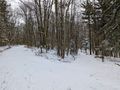
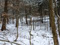
The trailhead area as we were walking in.
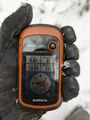
Made it!
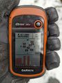
Accuracy.
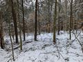
View Northish and down the hill.
View Southish and toward the trails.
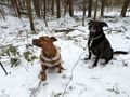
Hashdogs sitting at the hash, but refusing to look at the camera...

Stupid grin with dog butts in the background.
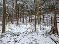
Before heading back, a view of the hash area.
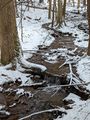
On the way back, we stopped at a couple places at the creek for the mini-waterfalls.
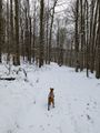
Getting back to the trail, the dogs enjoying themselves and running around.
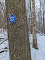
Christian Hollow trail marker, the closest trail to the hash.
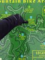
The trailmap at the trail intersection. I think the hash was actually closer to the 'W' on this map.


Ribbons
This user earned the Land geohash achievement
|
Pedalpusher earned the Consecutive geohash achievement
|