2022-01-16 40 -4
| Sun 16 Jan 2022 in 40,-4: 40.4869508, -4.1532926 geohashing.info google osm bing/os kml crox |
Location
30 meters behind a locked gate, on a sheep paddock, close to a bunker system, near Fresnedillas de la Oliva.
Participants
Plans
Expedition
This was the second expedition after 2022-01-10_40_-4 that I did as a mystery tour without checking out the geohash on the Maps beforehand. It was very close, only eleven kilometers to ride, as the navigation device told me.
At the exit where the navigation device wanted to leave the paved road, I could conveniently park the Goldwing. From there, I continued on foot. It was quite an interesting walk, although I could not reach the geohash in the end.
Could I have told from the Maps that the geohash was not accessible? I checked afterwards, and the answer is “probably not.” Walls are visible in the satellite view, but you can't tell how substantial they are and whether any gates are seriously locked or not. By the way, I saw on the Maps that the geohash was not inside the little round building, but a few meters away.
Tracklog
Photos
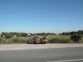
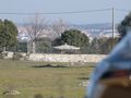
Parking the Goldwing by the side of the M-521. The geohash should be 315 meters from here, roughly in viewing direction. I suppose that's behind the bright wall on the other side of the meadow.
The meadow seems anyway to be inaccessible, so I walk a bit along the road — note the parked bike in the background — and then follow the path in the foreground, now aided by the Droid.
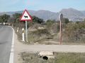
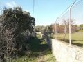
Terrain gets a bit rougher, substantial fence by the side of the path.
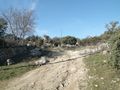
I pass by a quite extended bunker system…
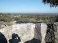
… with nice views.
Approaching the geohash. It is to the right, I hope behind where the wall with the fence turns right…
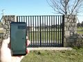
… but no, it's within this sheep paddock, about thirty meters behind this securely locked gate.
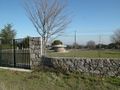
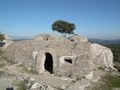
I estimate it to be close to, if not inside, this little round building.
Back at the Goldwing, I notice that the round building is visible from the parking place, so I put on the tele lens and take this photo. You can even spot it in the very first photo.


