2022-02-15 -37 145

| Tue 15 Feb 2022 in -37,145: -37.5664118, 145.3384963 geohashing.info google osm bing/os kml crox |
Location
Off the Mt Everard Track near Kinglake
Participants
Expedition
- Success!!! -- Johnwrw (talk) @-37.5664,145.3385 15:15, 15 February 2022 (GMT+11:00)
Between the members of our geohashing chat group, we had reached an impressive total of 7 consecutive days of successful geohashes, (with Felix alone managing the first 6 days in a row). Matt had kept the streak going with a ride out to near Trafalgar the morning before, but it was looking a bit unsure whether anyone would make it to a hash for day number 8. I didn’t take much persuading however to abandon my plans of doing anything else that day and set off for an adventure to Kinglake.
After packing, and leaving the animals at home (a cat and four chooks) with plenty of food just in case my expedition dragged out deep into the evening, I departed Footscray at about twenty to twelve. My first goal was to make the 12.21 Hurstbridge train from Westgarth, and after making very good time cycling across the inner North I had about ten minutes to spare.
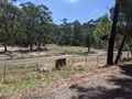
One uneventful train ride later, I arrived in Hurstbridge at about quarter past one, and got straight on the bike on the road to Kinglake. I wanted to take a good chunk out of the 20 kilometres or so of riding I had in front of me before stopping for lunch. The road wasn’t exactly ideal for cyclists, with zero shoulder most of the way, but thankfully the traffic was pretty light in the middle of the day, and all who passed me gave me plenty of room. The scenery was very pleasant however, with plenty of vegetation, and animals at regular intervals (horses, sheep, goats, alpacas, cockatoos) escorting me along on the up and down (though more up than down) 10km through to St Andrews.
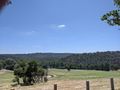
From this point onwards the ratio of up to down increased significantly. A few kilometres out of St Andrews I reached a very steep section, and aware that I still had quite a bit of riding left to do, I decided to not trash my legs trying to struggle to the top, and instead took the walking option. Right at the top of this hill, there was a nice shady spot under a tree with a bit of room away from the road, and it was here that I had my lunch at around 2pm – left over falafels, hummus, and tabbouleh from the night before with a couple of slices of my home-baked bread.
I did know that there was going to be climbing involved on this ride, but I hadn’t really done my research into exactly how much there was or how intense it would be, and this hill had me worried. Was the rest of the way going to be like this? How was my knee going to cope? A little bit of investigating on google maps reassured me though: While that last section had a gradient of around 10%, the climbing from here on looked like a fairly steady 4-5% - much more manageable!
So, stomach full, I set off again. An initial respite of a bit of a descent off Mt Lunch soon gave way to the climb proper up to Kinglake. All the way up was about 7km with 350m elevation gain but I only needed to reach the Mt Everard Track corner though, about 5km and 230m vertically. While this slope I could cope with, it was by no means easy. It had been cool and overcast down in the city, but up here I was bathed in full sun, and the mercury was up around 28 degrees. As I climbed, sweat started to drip off me like nobody’s business and I was starting to get a bit concerned about if I should have brought more water. I had almost finished my first bottle, had a bit more climbing yet to do on foot, and didn’t really want to get stuck into my last 500ml in my other bottle until I was safely on my way back towards civilization.
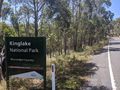
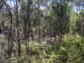
But I pushed on and despite feeling rather hot and bothered managed to reach the Mt Everard Track without feeling too many ill-effects. I locked my bike up to a sign, and felt good to press straight on. I had over a kilometre’s walk still to go along this fairly rough 4wd track (that my road bike would have been ill-equipped to handle), climbing 60m up around Mt Beggary before dropping 70m again on the other side. After this delightful stroll amongst the youthful forest (it having been burnt out in the Black Saturday fires in 2009), I reached the point at which I had to leave the track; the hash was but 60 metres to the west down a slight slope.
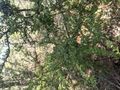
The understory was fairly open initially, and I made good progress. As I got very close, the vegetation got a bit thicker, but I was able to get myself to the geohash without too much difficulty, arriving at a quarter past three. A pleasant surprise right at the hash point was a Coprosma quadrifida bush with several ripe berries on it. There were a few others bushes around, but this was the only one I saw with fruit. I think it was in a more sheltered spot which could have delayed ripening, meaning there were still some berries for me to enjoy while the others were already all out for the year. After a quick nibble on these, I headed back to the track, and back towards the road. I got stuck into my second water bottle (and an orange) as I climbed back up Mt Beggary, feeling confident of my imminent return to civilization.
I got back to my bike, and sped down the hill towards St Andrews, though having to take a little bit of care around the corners. The ascent back up Mt Lunch was much less taxing coming from this direction, and led to another enjoyable downhill down the other side. I was soon in St Andrews, and I stopped off at the pub to refill my water bottles, but while I was there I thought I had better buy something too, so I got a pot of Carlton Draught to celebrate a successful geohashing adventure.
Once I finished my beer, I looked up the train timetable out of Hurstbridge, and discovered I really had to get moving! The next train was in just over half an hour and google maps estimated it was a 27 minute ride from here, and if I missed the 5.01 train I would have a whole hour to wait until the next one! By the time I was on the road again, I had just 31 minutes until the train was due to depart, but I rode hard and easily beat google maps’ estimate. I arrived with a comfortable 10 minutes to spare.
The train was very empty, it’s amazing how if you provide a shitty infrequent service no-one wants to use it. After Eltham where the service frequency picks up, surprise, surprise, more people got on. This train was a limited express, meaning that I couldn’t get off at Westgarth where I had got on initially, so I had to alight at Clifton Hill.
The ride home from here was fairly uneventful. I stopped for a couple of groceries I needed in Racecourse Rd, and took the opportunity while there to get an icecream as a treat and a gatorade, since I was still a little concerned about just how much I had sweat on that hill climb. I finally arrived home about 7 hours after I left, and all up, according to strava I rode 62km, but fell just short of a kilometre of elevation gained, with a total of 984m.
Photos
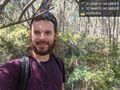
Made it! @-37.5664,145.3385

Gps
Horses
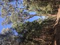
View from lunch spot
Entering the National Park
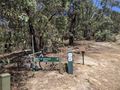
Leaving my bike behind
Along the track

Leaving the track
View from the hash
Coprosma berries at hash
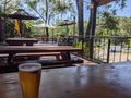
Celebratory beer at the St Andrews pub


Achievements
Johnwrw earned the Bicycle geohash achievement
|
This is hash #8 of the 2022 Victorian Geohash Streak.