2022-03-01 -37 145

| Tue 1 Mar 2022 in -37,145: -37.3486000, 145.0657043 geohashing.info google osm bing/os kml crox |
Location
In a plantation forest near Wandong
Participants
Expedition
It had been a rainy morning, but by the early afternoon it had started to clear up and the radar indicated that there shouldn’t be any more rain for several hours, at least not between me and the hash. When I had checked the location earlier in the day, I had thought that it looked quite simple to reach if I had wanted to get a train both ways with just a little ride out and back from Wandong Station, but where’s the fun in that? I decided that I would turn it into more of an adventure by riding all of the 75ish kilometres there from home and getting the train back.
I worked out that I could get out to the very edge of suburbia at Wollert pretty much entirely along bike paths, taking my normal route from Footscray up the stock route and across Royal Park to the bottom of the Upfield bike path. This I took up to Coburg North, before cutting across to join the Merri Creek path and taking this out to the ring road. Here I went east along the path that follows the ring road for a bit, before turning north again and heading up the Darebin Creek trail to Epping. From here it was just a few backstreets to reach the urban frontier.
I found it pleasing that my route used sections of all three of the main creeks in northern Melbourne between the Maribyrnong and the Yarra - Moonee, Merri and Darebin - although it was only a tiny section of the Moonee Ponds Creek that I followed connecting Racecourse Road up to Flemington Bridge Station.

I had to keep a close eye on the map going up the northern section of the Darebin Creek trail, since I had not ridden this way before, and it was one of those paths where it was easy to get misled by other paths intersecting at regular intervals, with it being far from obvious which was the right way onwards. I only made one wrong turn though, which I quickly corrected; a more serious issue, however, was some roadworks blocking the path at once stage which necessitated backtracking by half a kilometre to find an alternative way through.
Overall, it was a fairly straightforward journey to Wollert of about 40km, and here I was able to refill my bottles at a water fountain before moving on to the next stage of my adventure. Now the ride changed character to one of just following the main road north for 30km to Wandong. It was 5pm by this stage, a couple of hours after I’d left, and there was a reasonable amount of post-work traffic on the road. Thankfully the road had a decently wide shoulder most of the way, so I didn’t feel too endangered as long as I kept my wits about me. Before too long the traffic had reduced anyway, the peak having passed, and with a good chunk of the traffic heading off towards Whittlesea rather than continuing northwards.

I started to see many farm animals along the side of the road – cows, sheep, horses, geese etc. – but the most interesting was the deer enclosure I went past! I also saw a range of birds, like galahs and cockatoos. Sadly though, I also saw a squashed blue-tongue lizard on the road.
As I rode along, my glycogen levels were getting lower, the road was getting a bit steeper, so it was getting tougher going, but I wanted to push on past 50km before having a proper rest. Eventually I stopped and had some dried fruit and nuts, and plenty of water, sitting on the ground up against a stone driveway column. But then I realised I had ants crawling over my neck! And sure enough, when I looked at what I was leaning against, this had ants teeming all over it. Not a good spot to rest in the end.

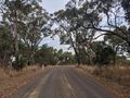
So before long I was on my way again, not feeling particularly well rested, but feeling good about the fact that there was now less than 20km to go until Wandong. The road became a bit less steep again, and the remaining distance went by fairly easily. I watched from afar Mt Fraser slowly go by on my left, on whose slopes Ned Kelly was born almost 170 years ago. I also kept myself entertained on this leg by running through in my head all the perfect squares from 12= 1 to 1002 = 10000. By the time I had finished this I was practically there. I rolled into Wandong around 7pm, and popped into the petrol station, where I bought a blueberry muffin which I ate immediately, and a couple of two-pack chocolate bars, three quarters of which I saved for later.
I then discovered that there was very little open in town, not even the pub was open. I did find an IGA where I was able to fill up my bottles again (but not sure why I didn’t do this at the petrol station). From here it was just a few more Ks to the hash itself. Slightly further north, before turning off onto a dirt road called Scanlons Rd. Along this for a couple of Ks, including a fairly steep hill that my tiredness combined with the state of the road meant that I felt more like walking up it instead of persevering on my bike.

Soon I reached the point at which I had to leave this road, and start heading down into plantation eucalypt forest, following tracks that google maps indicated existed, but for which no street view images existed (it being presumably private land from this point). It was still about a kilometre as the crow flies to the hash, so if the promised tracks let me down, it was a lot of bushbashing to do that I wasn’t sure I was up for.

The first section of track was fine, but definitely not rideable on my road bike, I left my trusty steed by the side of the track, and continued on foot. Soon I turned right and crossed a fence line but the gate on the fence was very little deterrence to my onward progress, having been absolutely mangled down to ground level.
This next section had clearly not seen vehicular usage for a long time. While I could follow the track without too much difficulty, it was covered in 2-3m high saplings that I was constantly needing to step through and around, brushing away cobwebs as I went. This was only for perhaps a hundred metres though before I joined a track that was clearly much more in service.

From here it was easy to get down to the closest a track would get me to the hash. Google maps had indicated a couple of small creeks to cross, which I was a little apprehensive about, especially after Lachie’s experience a couple of weeks ago, where he was foiled by a creek crossing. But as it turned out these creek beds were bone dry and no obstacle at all.
I had I think 80m to travel away from the track to reach the hash, and this was also very easy. Up a slight slope, but the forest was very open. The trees were more mature and had been clearly well thinned out, leaving just open grassiness between them. This was perfect conditions for macropods, and I saw several eastern grey kangaroos and wallaby of some sort. Unfortunately they were too skittish for me to get close enough to get a good photo though. But of course I did get a good pic of my own mug at the hash, along with a screenshot with the gps indicating that I was but centimetres away from the hash.

Job done, I got back to the track and started back up the hill to the road. Admiring the colours of the evening sky, I took a slightly different route than on the way down, avoiding the overgrown track, and I soon reached my bike again. By the time I was back in the saddle though it was getting quite dark, and I was regretting the fact that I didn’t have my lights with me. I had left them at home, dead flat, after I had failed to find the charging cord for them. But I got back into Wandong without incident, not a single car passing me, and just one going past in the opposite direction.
Now I just had to get the train home. Easier said than done. I got the station at 8:32 and discovered that I had missed the 8:22 train. I knew the last train wasn’t until after 10, so I knew the situation wasn’t dire, but I looked at the timetable and found out that there were no more trains until that last one at 10:25pm. Ahh. I had seen earlier according to google maps an 8:55 departure but I now realised that this was a train heading out to Seymour rather than back in to Melbourne. I really should I have checked the train timetable more closely. I definitely could have made it back in time for the 8:22 if I had faffed a bit less in Wandong the first time around, and moved with a bit more urgency in and out of the plantation, but I was at the time blissfully unaware of my predicament.

So I had almost 2 hours to kill in Wandong. The pub was shut. My phone was down to about 20% battery. My lack of lights meant that I couldn’t just get back on the bike and ride the 30km back into Epping for a metro train. What was there to do. By this stage the IGA was shut, but the petrol station was still open. I bought a passionfruit flavoured fizzy drink, a packet of chips, but just as I was walking out I spotted the newspaper stand. This presented a way to pass the time without draining my phone battery. The Herald Sun, the Australian, or some local paper were my options. The HS is brain-meltingly awful, the local paper would probably not be able to provide enough reading material, so I settled on the Oz. While hopelessly conservative, it is at least aimed at a more educated audience. I also checked the back and there was a cryptic there too that I could have a go at. Unfortunately there were no pens to be bought in the petrol station, and despite my best efforts, the guy at the counter didn’t want to let me walk off with one of his personal pens he had on the desk there. So, the articles it was.
So I went back to the platform, and waited. I read the paper, and drank my drink, and ate my snacks, including a peanut butter and cucumber sandwich on home-baked bread (even better than the last loaves) that I had brought from home. The time passed, the 8:55 to Seymore came and went, a couple of freight trains passed, a thunderstorm passed over, and eventually right on time, the 10:25pm pulled in to the station.
Surely it would be a straightforward trip from here. Nuh-uh! The train from Wandong to Southern Cross was uneventful, (and I appeared to be the only passenger on it), but at Southern Cross I discovered that trains weren’t running to Footscray! Oh joy. I could get a train to North Melbourne, but from there it was a rail replacement bus service, on which, of course, bikes could not be brought.
So rather than a 700m roll home from Footscray station on the footpath, I now had to ride five more kilometres, in the dark, without lights, and of course, by now it was raining solidly again. I eventually got home right on midnight, extremely soggy, and rather tired, but with the satisfaction that comes with a successful geohashing adventure. I don’t think I qualify for a drowned rat achievement since it wasn’t en route to the hash that I was soggified, but you need to know that I was very soggy.
Photos
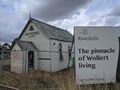
Doesn't look that pinnacular
Could have gone some hummus at this point
Could have gone a drink at this point
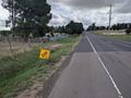
Wandong Goats
Off the bitumen
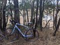
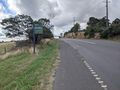
See you in a bit, bikey
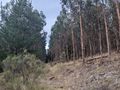
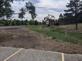
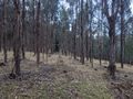
Plantation
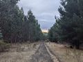
A better path
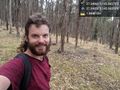
At the hash @-37.3486,145.0657

GPS proof
View from the hash
GPS proof
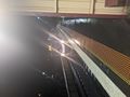
At last my train comes


Achievements
John earned the Bicycle geohash achievement
|