2022-08-17 42 -78
| Wed 17 Aug 2022 in 42,-78: 42.3896796, -78.7529534 geohashing.info google osm bing/os kml crox |
Contents
[hide]Location
In front of a driveway in East Otto on East Flats Road
Participants
- Pedalpusher
- Simon the dog
- Myka the dog
Expedition
I was getting ready for a big trip starting the next day for my girlfriend's birthday. We are traveling down to Tennessee for a long weekend and then taking the next week to drive back home. I still had some stuff to do to get ready so I was a little concerned about trying this expedition after work. Instead, I decided to take a long lunch (since we were in a slow section of our current Sprint and there wasn't a whole lot going on at work). I could then take the dogs and do a short hike at East Otto State Forest as well before coming back home.
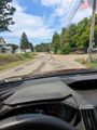
The drive down was uneventful and I followed my phone GPS to the hash-road. Having previously looked at the streetview, I knew the house/driveway to stop in front of as I kept an eye on my GPS. I was able to get a decent reading without having to get out of the car and got a couple pictures of the surrounding street. Turning around, we headed to the State Forest. After nearly missing my turn, I found the parking area and we started hiking up the forest road. I was really not expecting to see anyone out there, but about half of the primitive campsites we walked by had either a tent or RV set up. We only had time to walk to where the road forks before we had to turn around, but it was a nice hike and the dogs enjoyed stretching their legs.
Upon later review, this is the 256th (2^8th) successful Expedition!
Photos

Made it!
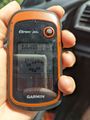
Accuracy.
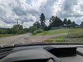
View East from the Hash.
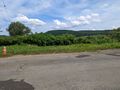
View North.
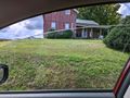
View South toward the house.
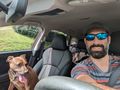
Stupid Grins and Simon in the back doesn't care. He was promised a run and we aren't there yet...
After turning around, a view West from across the street from the hash.
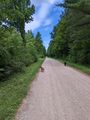
The dogs are finally happy running down the road in the State Forest.


Ribbons
This user earned the Land geohash achievement
|
Pedalpusher earned the Two to the N achievement
|