2022-09-04 46 -122

| Sun 4 Sep 2022 in 46,-122: 46.3411326, -122.9008918 geohashing.info google osm bing/os kml crox |
"We should start charging Hamblingreen for the gas on his failed expeditions."
Contents
[hide]Location
A deforested field north of the Cowlitz shooting range. North of Castle Rock, WA in the St. Helens graticule.
Participants
- Hamblingreen
- My parents. They were a bit more excited to go on a spontaneous adventure this time, perhaps due to the hours of nagging.
Plans
I'm writing this as we approach the hashpoint by car. This was the most viable option today considering the hashpoints in the other graticules surrounding portland were further away and the portland hashpoint for today is in the middle of someone's house. We'll drive down I5 until just north of Castle Rock, where we'll turn off onto a logging road and hike about a quarter of a mile to the coordinates.
Expedition
Things did not go as planned. Just a little bit down the logging road we encountered a massive gate with many "NO ACCESS" signs. Apparently you needed to lease the land from some company, and we couldnt even walk the extra mile down the road to the hashpoint. Foiled!
Distractions and Detours
The opposite direction down the road, however there was access to the Toutle river. We decided to hop down there and get our feet wet, and had a nice time. We saw a bunch of salmon fry swimming in a stagnant portion of the river, it was really cool! By the side of the road, I saw some trash that I decided to pick up. Why not?
Photos

Thwarted again!.
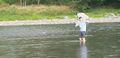
We got a little sidetracked...
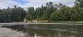
Beautiful river that I wouldn't have seen today

Even though we didnt reach the hashpoint, i can's help but smile!.
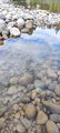
Salmon fry in the Toutle river.


Achievements
Hamblingreen (talk) earned the Two to the N achievement
|