2022-09-08 42 -78
| Thu 8 Sep 2022 in 42,-78: 42.9558313, -78.6121947 geohashing.info google osm bing/os kml crox |
Contents
[hide]Location
Edge of Tillman Road Wildlife Management Area
Participants
- Pedalpusher
- Simon the dog
Expedition
When the hashpoints were published, I didn't like how far away it was, but it was also on public lands that I've never been to before. Looking at the satellite pictures and the DEC Map of the area, I thought this would be easily reachable. Plus, being public lands, Simon could get a good hike in at the same time while we explored a new area. Initially, I thought I would be able to drive down the road right next to the highway, but upon further review, the 'road', turned into a dirt track and went through a field that looked like it occasionally has giant puddles. So I played it safer and drove around to the designated parking area after work. In my initial research, I figured I could walk down the road to that corner and walk down the property line on the path I saw in the Streetview, then either walk through the woods to the trails or walk back and then hit the trails.
As we were getting ready to walk to the corner, I thought maybe I should just walk down the trail and cut through the woods when I got close, but I knew there was a large pond on that side and figured it would be better to explore and we walked to the corner anyway. Very glad I did it this way, because ALL the way down, the sides of the old road were made up of the thickest brush and shrubs with no way to get through. Nature was taking over, but you could still see the asphalt in the middle where people were still walking regularly to keep a path open. Halfway down, the right side opened up and there was easy access to the small lake so we stopped for Simon to get a drink and cool off for a bit. I tried skipping a couple stones, but either my skills have failed me or I had really bad rocks and only managed to get 3 skips or less (I'm going to blame the rocks, because they really weren't that great to start with).
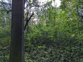
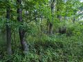
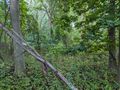
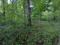
Continuing down the road, We got to the wooded area with the hash, but the shrubs were still pretty thick. I did get lucky though because right near the hash was an animal trail and the bushes weren't quite as thick as everywhere else. I walked to the end of the road, just to be sure, but that small opening was really the best option. Squeezing our way through, the shrubbery wall was only a couple meters thick and I was then able to move more freely around the hash area. I then realized I got even luckier as it was open right at the hash, but had I tried getting here through the woods, it would likely have been quite the ordeal as things got real tight and overgrown all around. Getting my pictures, I headed back to the road and around before walking the Southern half of the WMA. With a little daylight left, I decided to hit the trail on the Northern side by the parking lot for an additional 10 minutes and right as my alarm went off, I found the main boardwalk by the other parking area. So we walked on that before turning around and heading for home. It was a pretty cool area to walk around, and while it was popular (there were a bunch of cars in the lots), the WMA was large enough that I never ran into anyone.
Turns out that Tomorrow's Geohash was reachable again in my favorite place to go for an adventure to make this the first in a Consecutive streak.
Photos
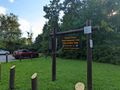
Parked in the lot.
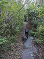
Walking down the old abandoned road, you can see nature is growing over, but there's still some of the road showing through for now.
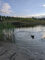
Simon playing in the water.
Made it!

Simon is really selling the Stupid Grin.

A much nicer pic of Simon at the hash.
View West, toward the old road we walked in on.
View South from the hash.
View East, but we aren't going to make it to the trails going through there.
View North.
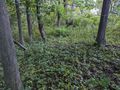
A look back, a view of the hash.
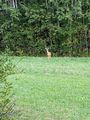
Rounding a corner on the trails now, there were a couple Whitetail deer in the field.
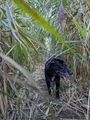
At the southernmost section of the trail, we were on a boardwalk through a marsh, but the plants were still towering over and around us.
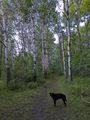
A nice grove of Aspens on the trail before we made it back to the main road.


Ribbons
This user earned the Land geohash achievement
|