2022-09-09 42 -78
| Fri 9 Sep 2022 in 42,-78: 42.0814409, -78.7716468 geohashing.info google osm bing/os kml crox |
Contents
[hide]Location
Allegany State Park, just off the Conservation Trail
Participants
- Pedalpusher
- Simon the dog
- Myka the dog
Expedition
ASP! How could I pass this up when it was right next to a trail and make a Consecutive Hash (starting expedition here)? I was planning on going to my girlfriend's place to spend the night since we had a wedding on Saturday afternoon to go to. I figured I could squeeze this in if I left right after I finished up with work and possibly stop at the Lockport hash which was right on the side of the road for a Double.
Texting my gf, she was cool with me showing up later in the evening so plans were set! Late in the work-day, I got the dogs ready and got my stuff together for the weekend, but even that wasn't enough time and I wasn't thinking as clearly as I should have been. I had everything I needed for the weekend, but I neglected my evening adventure. It wasn't until I parked that I realized I didn't bring any water or snacks with me, but figured it would be ok as it wasn't a long hike.
Heading up the trail, we got to the top of the first ridge where it flattened out for a while and we're still walking and not getting to the first fork in the trail...it's gotta be around the next...no...next?...bend? Finally getting to the other trail, I turned on my GPS and saw I still had a mile (1.6KM) to go...perhaps this trail was longer than I remembered, but I then realized I never looked that up either. So unprepared...
We finally made it to the North Country Trail merge and rounded the corner with about 0.3 miles/0.5 KM to go. I was then able to cut off the trail at the closest point and walked the remaining 100 meters and had a good old GPS dance to close in on the spot. Getting my pictures, I knew it was getting darker and the sun was close to going down. Guess what else I didn't have...lights! I knew I would be able to get most of the way down before the sun fully set, and figured I could use my phone light if it got too dark, but I would have to hustle.
Getting to the second NCT/Conservation trail split, there was a sign that indicated the Admin building where I parked, was 2.2 miles (about 3KM) away. It was gonna be close, but I ended up not needing my light fortunately. As we broke out of the woods, we got to see a bunch of deer on the grassy hillside behind the Admin building which was cool. I then fed the dogs their dinner at the car and got a big drink from a water fountain inside before heading for J's place. Since my expedition took way longer than planned, and I was tired from moving more quickly than I normally would have hiked, I decided to skip the second stop and just go to bed.
Being the weekend, I could already see that my Consecutive hash would end here as there wasn't anything close that was reachable (both the Buffalo and Dunkirk hashes were clearly on Private Property and pretty far away as well).
Photos
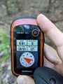
Made it!
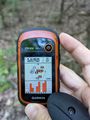
Accuracy.
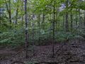
View West-ish and away from the trail.
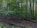
View South.
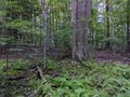
View East, lots of trees
And, yep, more trees to the North.
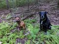
Hash Dogs sitting nicely at the hash.

Stupid Grin, not truly worried yet. Perhaps just a little nervous.
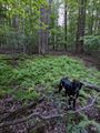
View of the hash, before walking back to the trail.


Ribbons
This user earned the Land geohash achievement
|
Pedalpusher and Simon earned the Consecutive geohash achievement
|