2023-05-06 45 -120
| Sat 6 May 2023 in Goldendale: 45.6588556, -120.9712620 geohashing.info google osm bing/os kml crox |
Location
This Geohash is located on a rock in Wishram.
Participants
Plans
Easternmost of two, er, three geohashes - then on to a friend's house
Expedition
After failing at the previous expedition, I had high hopes.
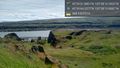
Pre-expedition research with Google maps shows this to be on top of a big rock. Big, because of the shadow in the overhead image (nearly the same on Bing). The rock has to be accessible, there is a metal tower west of the hashpoint. Right? The only thing to do was to figure out how to get to the top of it.
The first photo was very much from the top, on Boulder drive. Nowhere to park here, and clearly owned land between the two.
I progressed down to Bluff road, thinking I could find a parking spot and maybe backtrack slightly, or ambassador my way past the property noted above. This was a narrow one-way road, and my Prius was quite out of place among trucks with stickers and flags for the other party. Hrmm...
From the bottom, I snapped a second picture - I was not climbing up this rock today.
Without a way to get to the hashpoint, I would have to leave this one unvisited. My previous trip to the graticule (nearly 13 years earlier) would have to remain my only success.
Tracklog
Photos
Above... @45.6623,-120.9722

