2023-05-08 48 7
| Mon 8 May 2023 in 48,7: 48.0806450, 7.0582343 geohashing.info google osm bing/os kml crox |
Location
On a ski slope at Le Tanet, in Soultzeren.
Participants
- Baarde
- several unidentified hikers
Expedition
Le Tanet is a mountain and a ski resort in the Vosges mountains. Today's coordinates were located on the blue piste Les Myrtilles (Blueberries).
I was reluctant to walk 10 km (and back) with more than 700 metres of elevation, just to visit a geohash. Fortunately, I good friend of mine had planned a two-day hike in the Vosges and I had expressed my interest in tagging along for a portion of the journey. So when I realised that he was going to pass just 600 metres from the coordinates, of course I was on board!
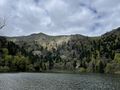
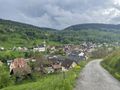
We took the 11:14 train to Metzeral and started walking toward the mountains. After a short hike, we arrived at a small lake, where we ate lunch and met an acquaintance, then at a larger lake. From there we had a steep climb up to the ridge that separates the departments of the Vosges and the Haut-Rhin. Shortly after, we arrived on top of the Hohneck, the third highest summit in the region. We drunk a radler at the mountain hut, then walked along the ridge until we arrived near the peak of Le Tanet.
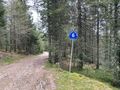
I would have loved to get the Drag-along achievement, but my friend wasn't keen on descending 200 metres that he would then have to ascend again. So we decided to part ways. 10 minutes later, I crossed the ski piste and reached the coordinates, on a hiking trail at the edge of the piste. I can attest that several unidentified hikers earned the Land geohash achievement today.
After recording proof, I departed quickly and started racing down the mountain, because the last train of the day was departing in 102 minutes from Munster, 10 km away. Running down on mountain trails is fun, running down on asphalt isn't: when I arrived at the train station, my feet were starting to ache a little, but I had made it! 27 km hiked, 1116 metres of elevation, and a new Move record, for an epic geohash.
We met many hikers during this expedition. The trails are nice and well marked, the views beautiful, and a lot of people took advantage of the holiday to go hiking with friends and family. In the train to Sélestat, I chatted with a couple of Parisians who had spent the weekend hiking and were now going back home.
Photos
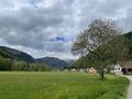
Leaving Metzeral
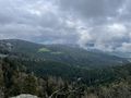
Going up the mountain
Near Le Tanet
Walking down the piste
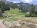
Les Myrtilles and the coordinates

Coordinates reached

Stupid grin
Going down the mountain


Achievements
Baarde earned the Land geohash achievement
|
Baarde earned the Massive Climb achievement
|