2023-05-14 45 -122
| Sun 14 May 2023 in 45,-122: 45.5896850, -122.4033448 geohashing.info google osm bing/os kml crox |
Location
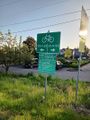
In Camas, at the Crown Zellerbach Power Ditch!
Participants
Plans
Michael5000: Back when I only used satellite imagery and a high-quality GPS unit, I would have seen this hashpoint as unreachable, seeing as how it is clearly two or three feet behind a barbed-wire fence in a concrete ditch. However, the phone app came along with its softer expectations about GPS precision, and I think this slight fuzziness about what constitutes "there" makes geohashing more fun. So heck yeah -- at some point on Sunday, I will one way or another make it to this hashpoint -- or at least "as close to it as GPS gets."
Expedition
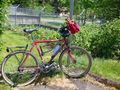
It was a beautiful sunny day for a long bicycle ride, plus I got to see plenty of planes, trains, and river barges, but wow, what a headwind! It was blowing very hard out of the east, which made the outward half of this journey pretty thirsty work. It did give me a tailwind going north and uphill across the Glen Jackson Bridge, which was nice, but otherwise it was pretty tough going.
The first 15 miles were more or less an exact duplicate of last Tuesday's Expedition, but this time I continued on an additional 8.5 miles to the little town of Camas, and specifically to the Crown Zellerbach Power Ditch. It's fun to say "Power Ditch!" but it's just a canal to bring water to a power generator at a nearby paper mill. It's a mill race. And, it doesn't look like it has been used for a while. The hashpoint was right by a church parking lot as well, which I suppose would qualify it as a Holy Hash.
That being taken care of, I went to a fast food restaurant to rehydrate and fill my water bottles. I took the return leg in two stages, stopping again at a coffee shop on the Oregon side of the bridge to rehydrate again and get some lunch, and also to get out of the sun for a bit. It went much, much faster with the brisk tailwind, though.
The total round-trip distance for the trip was 48 miles (78 km), the furthest I've ridden for a bicyling hashpoint by quite a ways.
Tracklog
The 2023-05-09 45 -122 Expedition in red, the 2023-05-14 Expedition in blue.

Photos
On Tuesday, I turned right. Today, left.
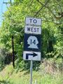
Washington highway signs are fun
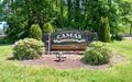
Arriving in Camas
At the hashpoint
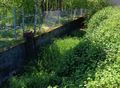
Power Ditch!
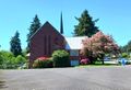
A church, from the hashpoint
Yep
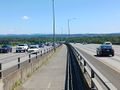
You never tire of the Glen Jackson Bridge
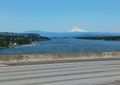
Nice views off the side, though


Achievements
Michael5000 earned the Bicycle geohash achievement
|