2023-09-12 56 -4
| Tue 12 Sep 2023 in 56,-4: 56.3414617, -4.7290586 geohashing.info google osm bing/os kml crox |
Contents
[hide]Location
On a hill near Inverarnan, roughly 1km from the roadside.
Participants
Plans
KerrMcF
This will be my second geohash and Daniel's first. I plan to pick Daniel up at around 3:30pm before heading to the point together. This expedition took place before Daniel's account creation.
Expedition
KerrMcF
I left my house at around 3:10pm, expecting to arrive at Paisley Gilmore Street Station at 3:30, but traffic delayed this to 3:45. After spending 10 minutes directing Daniel to the car, we began the hour-long drive to the geohash. 20 minutes into the drive, we began to notice temporary signs indicating that the road we needed to take to the geohash was closed. After confirming that this was definitely the route we were taking and that the alternative route would add an additional hour (Scottish Highlands), our hopes were not high. We continued anyway on the off-chance that when we reached the point of the supposed road closure in 20 minutes it would have cleared.
As it turned out, we had timed the drive perfectly. The road was closed temporarily due to a crash (this specific road is incredibly winding and people often take the narrow corners far too quickly) and yet 3 minutes before we approached the area highlighted as closed, it became opened again with the advice to take caution in the area. Although we couldn't believe our luck, another issue of actually identifying which of the small sideroads we were supposed to take arose. By the time we figured it out, we had just passed the correct place to stop. Due to the nature of the road, we had to travel another 8.5km before being able to turn back and try again.
After finally parking in an incredibly useful spot that almost seemed designed for this very thing, we began the climb up to the point. Daniel had recently injured his knee quite badly and we knew that we needed to take it slowly. Due to this, we were unsure whether we would actually be able to make it to the point once we had to go off-road up the hill. Despite this, we continued on, crossing over a railway bridge and admiring the surrounding mountains until we reached where we needed to leave the road section. Immediately after seeing the path we would be required to take, we knew it would not be possible. The hillside was far too steep to climb safely and, although the online terrain imagery suggested the area from the road to the point was flat, it seemed the point was actually at the peak of this section.
For safety, and knowing that the experience itself is really the main goal of the expedition, we decided it would be better not to attempt to reach the point itself and turned back towards the car. We drove back to Cameron House to get some food before heading back to drop Daniel off near Howwood. He enjoyed what was his first attempted geohash and I was glad to have his company, so although technically a failure, I would consider this to have been a successful experience in every other aspect.
Photos

One side of the railway bridge
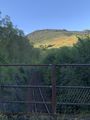
Other side of the railway bridge
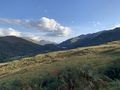
View from a location near to the hashpoint
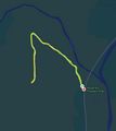
Tracklog of the walk there and back


Achievements
KerrMcF earned the Two to the N achievement
|
KerrMcF and Daniel earned the Done with Nature consolation prize
|
KerrMcF and Daniel earned the Cliffs of Despair consolation prize
|
KerrMcF and Daniel earned the Prize poultry Consolation Prize
|
KerrMcF and Daniel earned the Done with Cliffs of Poultry Consolation Prize
|
| Expedition Navigation | ||
|---|---|---|
| KerrMcF's expeditions | Next | |
| No Previous | Daniel's expeditions | Next |
- Meetup on 2023-09-12
- Meetup in 56 -4
- Meetup in Stirling
- Expeditions by KerrMcF
- KerrMcF's expeditions by car
- KerrMcF's expeditions on foot
- Two to the N achievement
- Done with Nature consolation prize
- Cliffs of despair consolation prize
- Prize poultry consolation prize
- Combo achievement
- Expeditions
- Expeditions with photos
- Coordinates not reached
- Not reached - Mother Nature