2023-11-09 64 23
| Thu 9 Nov 2023 in 64,23: 64.0351866, 23.6722308 geohashing.info google osm bing/os kml crox |
Location
In a field near Velhonperä, Himanka, Kalajoki.
The point on a topographic map: [1]
Participants
Plans
Looks like a good opportunity to get the virgin graticule. My current plan is as such:
- Take the bus from Oulu to the nearest bus stop (16:30–18:52), bring the bicycle
- Cycle to the geohash and to Kannus railway station (1 h 41 min to cycle 23 km)
- Take the train from Kannus to Oulu (20:33–22:15)
- If the bus is too much late, I can abandon the expedition, stay in the bus all the way to Kokkola and board the same train there at 20:14.
It will not be easy to pull off, but I believe I can do it.
I still have time to consider if I want to go or not.
Six hours later: ready to go!
Expedition
I left from work at about 16:15 and cycled to the bus station where the bus to Kokkola was already awaiting passengers. In hindsight, I could have gone to the Oulu slip road bus stop which would have been closer but perhaps less convenient on the whole. The weather was nice and cool: cloudy and around −1 °C. Roads in Oulu were frozen and covered in slippery ice in places, but I have studded tyres, so it was no issue. The temperature in Himanka was expected to be 0–1 °C, so not freezing, but gravel roads might still be frozen and fast to cycle.
In Raahe, the bus was ten minutes late. Not too bad yet, but every minute lost would increase the required cycling speed to reach the railway station on time. Then, an hour later in Kalajoki, the bus was eight minutes late, so it was still looking good. At the destination bus stop, 13 minutes late again. I got off the bus and quickly began to cycle to the hashpoint. I still had an hour and 28 minutes, so I was not in a too bad hurry... Or so I thought.
I got a very undesired surprise immediately after getting going again. It was indeed not freezing, and it had been snowing here so that the field road towards the hashpoint and the gravel road towards Kannus felt like cycling on fresh oatmeal. I could barely keep an average speed of 18 km/h, and even though I was making good progress, time was also running out fast. I felt like I was pedalling for my dear life as missing the train would have necessitated taking a very awkward train route later in the night.
The visit to the hashpoint itself was rather uneventful. As I had expected, the field had likely been active in the summer, but now in November I could walk there freely as there was absolutely nothing growing, just a layer of fresh snow covering the soil. I parked the bicycle, made a quick walk to the hashpoint, took the necessary photos, walked back and carried on as fast as possible. It was extremely dark, and I did not even bother trying to take good photos. I would have needed time to play with a light source, and even then I would have only made myself somewhat visible to the camera.
After about 15 kilometres, I finally reached a paved road and could speed up and do an average speed of 22 km/h. I watched the glow of the city lights of Kannus slowly get closer and closer while the GPS distance to the railway station steadily decreased. At some point, a loose dog came from a yard and began to chase me barking loudly. I had to speed up to about 30 km/h and pedal as hard as I could for a couple hundred metres until it finally gave up. I was not afraid of the dog itself, only the possibility that it would slow down in front of me and I would collide with it. When I had three kilometres and 17 minutes left, I started to believe that I would make it after all.
I arrived at the railway station at 20:27, six minutes before the train's scheduled arrival time. There, I was kindly informed by the information board that the train would be twelve minutes late, so I suddenly had a bit of time to spare. I quickly cycled to the nearest R-kioski and bought a little something to eat since I was getting hungry after the heavy exercise. I went back and boarded the train once it arrived. On the way to Oulu, it caught up with the schedule and arrived on time. I got off and cycled home.
According to the GPS receiver, the length of the trip was 354.9 km, of which I cycled 30.4 km, walked 0.4 km and travelled 164.5 km by bus and 159.6 km by train. The trip, including tickets, bicycle transport fees and food, ended up costing 72.90 €. Travelling is not too cheap here!
Tracklog
I lost the GPS signal in a couple of occasions, which shows up as more or less visible jumps in the tracklog.
Photos
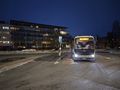
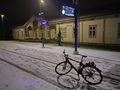
At Oulu bus station, the bus is about to depart.
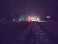
After getting off the bus.
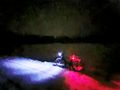
The bicycle parked on the field road, about 60 metres to go.
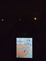
Proof of location.
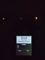
Proof of date and time.

Selfie in the dark.
Just arrived at Kannus railway station.
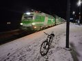
The train is arriving.
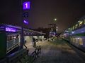
Back in Oulu.


Achievements
Kripakko earned the Land geohash achievement
|
Kripakko earned the Public transport geohash achievement
|
Kripakko earned the Graticule Unlocked Achievement
|
Kripakko earned the XKCD-100 Honorable Mention Achievement
|