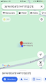
2024-01-29 -36 144
| Mon 29 Jan 2024 in -36,144: -36.7668331, 144.2172185 geohashing.info google osm bing/os kml crox |
Location
In Bendigo Regional Park
Participants
Expedition
This expedition was a last-minute choice - I thought that I would be too tired or too busy that day, but neither of those turned out to be true. With the only available Geohash in Melbourne located on private property that day, I decided I would go to the one in Bendigo, because it seemed easy to reach.
After some quick breakfast at Macca's, I hopped on the Echuca/Moama train at Southern Cross Station and transited for two hours until I reached Bendigo. The V/Line services are quite nice to be in - the seats are fairly comfortable, and there's bathrooms and water fountains on the train.
Once I got to Bendigo Station, I boarded the Bus Route 54 to Maiden Gulley and got off at Sparrowhawk Road. All I had left to accomplish was a 20-minute walk.
Outside of town, I suppose it's expected you're getting around by car, because there were no footpaths. It was a bit awkward, but no challenge. The real kicker is that there was a dog in someone's property who saw an unknown pedestrian around these parts as a very obvious abnormality. It started barking, which got other dogs barking, and very quickly there was howling, dogs fighting amongst each other, owners frantically shouting at their dogs to calm down. With no way to alleviate the situation, I just sorta sheepishly continued on (without the red balloons, obviously).
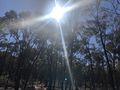
I shortly made it to the Geohash after entering the park. Just as I saw through Street View before venturing here, the bushes off the trail (including where the Geohash is) were not too dense. As expected, the GPS was a little fuzzy, but I'm certain that after walking in circles a few times (and nearly walking into the web of a funnel web spider), I've definitely stepped within a metre of any point that the Geohash could have been. Oh, and I forgot to take a selfie.
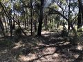
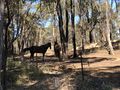
I decided to make "not upsetting the dogs again" an excuse to take the longer, more adventurous route on the way out; I would walk north from the Geohash, exit the park, and board the bus. This turned out to be the highlight of the trip - it was a very nice expedition through the forest, exactly what it's preserved here for. I nearly had some trouble navigating around private property as I tried to exit the park, but I found an intentional gap between two properties I could walk through, just south of the lake. There were horsies in one of the yards!
Encountering the horses was a bit more awkward than you might think. Like, you're aware that they're pretty sentient and social, but what do you do? Wave? I just kinda awkwardly focused on making the right amount of eye contact. Not too little (like, "ugh, a horse, I don't even wanna look at you") and not too much. Was I overthinking it? Probably.
After that, I took the Bus Route 54 back to Bendigo Station from the stop at Braedene Drive and then took the train back to Southern Cross Station.
Photos
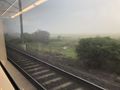
On the train
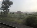
Still on the train
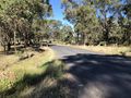
No footpaths, unfortunately
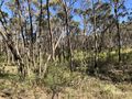
Bendigo Regional Park
GPS Proof
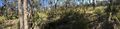
Panorama of the Geohash
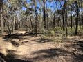
Traveling north out of the park
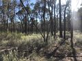
The journey continues
Eastbound!
The exit can't be far now.
Horsies!


Achievements
BarbaraTables earned the Land geohash achievement
|
BarbaraTables achieved level 1 of the Minesweeper Geohash achievement
|
BarbaraTables earned the 2-in-a-row achievement
|
BarbaraTables earned the Public transport geohash achievement
|
BarbaraTables earned the Two to the N achievement
|