2024-02-12 32 35
| Mon 12 Feb 2024 in 32,35: 32.5944042, 35.2787732 geohashing.info google osm bing/os kml crox |
Location
In a field south of Afula. Some satellite photos show a path through the field very near the point; others don't.
Participants
- MetricSystemDude
- Yerushalmi and his father
Plans
The previous day, MetricSystemDude and Yerushalmi planned to meet up at this geohash in the morning, despite both of them being unsure if this geohash is accessible. Google Maps' satellite view showed this geohash was on a path in the middle of a field, but as Yerushalmi noted: "One should never assume that dirt paths in satellite photos still exist".

MetricSystemDude, being fired from his job on that day, saw it as an opportunity to go on more expeditions. Moreover, he had the brilliant idea of calling the youth village to the north of the field in which this geohash is located, in order to find out about more information about this geohash's accessibility. He tried calling, but no one picked up the phone. He made note to try again in the morning of the expedition.
Expedition
MetricSystemDude
I woke up in the morning to a message from Yerushalmi, saying that he's gonna attempt getting to this geohash as well. I quickly packed my bag and looked up the route to the closest bus stop to this geohash, from which Yerushalmi and his father kindly picked me up when I got there later.
I did not forget to call the youth center - However, the poor secretary was not prepared to hear about geohashing this early in the morning. I confidently presented myself as a member of Geohashing Israel, and kindly asked her about the field south of the youth center, and whether she thinks it's accessible or not.
She was very confused, and told me:
"I don't know about any fields south of this youth center."
Determined to find out more information, I asked her in the most serious tone I could muster:
"Please, look out of the window to the south, and tell me what you think."
The secretary was flustered by my question, and after a few moments answered:
"I'm sorry, it doesn't work like that. Maybe you should speak with the Afula municipality and they might be able to give you an answer"
I then thanked the secretary and hung up the phone. Being traumatized by past experiences with Israeli automatic call routing systems and municipality workers' unfriendliness, I left home and headed towards the station in Karmiel, from which I was supposed to take bus line 242 to Afula.
Around the time bus line 242 was supposed to arrive, a suspiciously numbered bus approached the station - it had the number 0 on its front display, which in Israel means the bus is currently not on service. As I was looking more closely at the bus, which color seemed to match the color of the supposed bus line 242, and I suspected this could actually be the bus I had to take, despite the number 0 that appeared on the rectangular screen on the its screen. I looked at the bus driver in the eye, which magically made him stop. I asked him if this is bus line 242, to which he responded yes, and briefly explained that the confusion was caused due to a communication error. Fun fact - those errors happen way too often in Israel, so my sixth sense saved me about an hour long wait for the next bus.
Finally, I got on the bus, and about an hour later, got off in Afula.
Yerushalmi
My brother had a baby boy last week, so my parents are in the country for the bris. Although my father almost certainly cannot comprehend why I like geohashing, he agreed to go with me, after which we would go to Haifa to do some genealogy research, then to Tel Aviv to drop off my wife's artwork at a gallery, then to Rechovot to give somebody an Amazon package that was misdelivered to me.
I contacted the other geohashers in the country, but only MetricSystemDude was available. I warned both him and my father that the likelihood of success was low: I have found many times upon reaching what satellite photos told me were two fields with a path between them that they had been merged into one.
My father picked me up in my brother's car, and we drove to Afula. On the way we coordinated with MetricSystemDude that we would pick him up at the bus stop.
After picking him up, we used Waze to navigate to the point, but it brought us to a road west of the point and farther than we could've been. There were dirt/mud paths that might have gotten us closer, but the car probably wouldn't have been able to handle them.
Instead I recommended we drive to the cemetery, which was closer to the point. We went back north, hooked around east and then south again, and found a place to park. Then we walked towards the field.
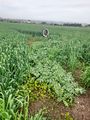
There hadn't been recent rainfall, and yet there was mud - either from non-recent rainfall or irrigation. But the crops in the field were fully grown, and a photograph taken angled downward from high above my head didn't see any break in the crops that might indicate a path:

Thus resigned to failure, we decided just in case to walk around the field to the east, then south, then west again, to where the entrance to the path would be if it were there. The amount of mud only increased as we went, and my father grew more and more concerned over what we would do to my brother's car when we got back in it.
And then we reached the entrance to the path. And lo and behold:

It was there! It was actually there!
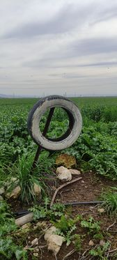
This is the part where my father decided to stay behind on cleanliness concerns, so MetricSystemDude proceeded on our own. In the distance we saw, for some reason, a tire on a stick smack in the middle of the field. And as we grew closer, and closer, two things became clear:
1) The path's purpose was, for some unimaginable reason, to lead to the tire on the stick.
2) The tire on the stick was, somehow, exactly at the coordinates.
As we went further into the field the path narrowed but didn't close up entirely. And then, suddenly, we were there!
God only knows who put the tire there and why. God only knows how the coordinates ended up in the one place in the field that it was possible to reach. God only knows how - but God smiled upon us that day.
We walked back to my father, who still refused to go into the field (especially after he saw what we had done to our boots). We returned to the car, cleaned off our boots extensively so as not to dirty the car, and then had lunch at HaAchuza Grill Bar (if you ever go to Afula, go to this place). Then we drove to Haifa and, after brief confusion thanks to GPS jamming, dropped MetricSystemDude off at the train station.
Photos
MetricSystemDude
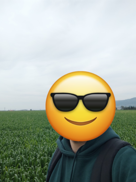
MetricSystemDude's Stupid GrinTM
The Geohash
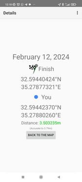
Proof


Yerushalmi
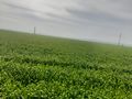
Scouting over-the-head photograph fails to reveal a path
Proof
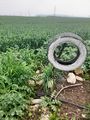
The tire at the point
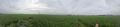
Panorama at the point
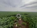
Slightly wider view of the clearing with the tire
Poison ivyish stuff

The Path of God


Achievements
MetricSystemDude and Yerushalmi earned the Land geohash achievement
|
MetricSystemDude earned the Public transport geohash achievement
|
MetricSystemDude earned the Two to the N achievement
|
MetricSystemDude earned the Meet-up achievement
|
Yerushalmi earned the Meet-up achievement
|