2024-03-30 56 -4
| Sat 30 Mar 2024 in 56,-4: 56.0043165, -4.6374159 geohashing.info google osm bing/os kml crox |
Contents
[hide]Location
About 200m off the John Muir Way near Balloch.
Participants
Plans
KerrMcF
My dad plans to spend the afternoon at the Cameron House Marina cleaning and generally maintaining our boat. We'll both head up together in the early afternoon and have lunch on the boat before I leave for my walk to the point and back. The boat itself will be considered as the starting point for this expedition due to it being a reasonably permanent location in my life.
Expedition
KerrMcF
We left a bit later than planned to head to the marina so I ate lunch in the car on the journey instead. I started my walk to the point at exactly 2pm, as I had to get back by a certain time. This meant that I would not be able to be at the point at 4pm so I would not achieve my first Saturday 4pm meetup. The walk to the point was mostly uphill with very few flat or downhill segments. I heard the same gunshots as I had heard during 2024-03-23 55 -4 and this time passed by a sign pointing towards the 'Shooting School'. I'd noticed this existed after the mentioned expedition but seeing the sign today confirmed to me that we would likely have been fine to continue our expedition beyond the point at which we stopped.
It wasn't too long until I reached the point at which I would need to leave the path - around 50 minutes into the expedition - but I wasn't overly confident that it would actually be accessible. I decided to go to find the nearby geocache first and then decide on my way back, so I headed towards that. I had researched it before, and I knew it was at the T-junction ahead, but I had no signal in the area around the geocache spot, so I couldn't figure out the precise location it was meant to be in. I didn't want to waste too much time looking for this; I'd realised it definitely would not be visible from the geohash point regardless of whether I found it or not, and I already had the honourable mention for the achievement from 2023-08-17 55 -3.
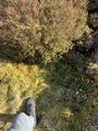
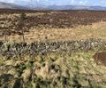
I started heading back towards the geohash point's general location, and for some reason had a growing sense of confidence. I can remember at the time thinking "If I don't make it, at least I can say I tried." Maybe that's what motivated me to leave the path and start trekking through the massive amounts of heather and grass towards the point. I also remember thinking that I could turn back at any time, that it was probably just worth going as far as I could to the point just to see how close I could get. I was definitely right, as within 10 minutes of walking through the heather, I had made it to the point. The ground towards the point had been a bit marshy at points, with some areas containing what was apparently sphagnum moss, resulting in bog-like conditions. I had managed to avoid stepping into this for the entirety of my walk to the point itself. Bear this in mind for the rest of the report.
I took my photos at the point, including my screenshots of proof, a photo of the geohash point itself, a panorama of the area (which includes the insane amounts of heather, as well as a view of Inchmurrin), and my Bereal as per my usual tradition. I also took a photo of a nearby wall. This wall is part of the boundary between West Dunbartonshire and Argyll and Bute. If the geohash had been .0001 degrees further north, I would have geohashed in a new region.
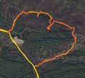
I decided, for some reason, that it would be better, faster, and easier to go back to the path on a different route. Initially, I planned to head to an indent in the forest that led back to a flat and open rock area next to the path as this seemed more direct. I quickly learnt that this indent was actually a muddy stream, which I would decide not to walk along. You can see on my route log that I spent a lot of time in this general area; as it turns out, the ground can turn into quite a severe bog quite quickly when you're not looking. I remember that at one point I stepped onto what I thought was dry ground only to find myself shin-deep in a bog - not fun. I continued in this area for 10 minutes or so before deciding to turn back.
I'm not ashamed to admit that I was mildly panicking at this point. I'm not too sure why; I was able to rationalise that I was not in danger, I was not lost, and I knew how to get out, but I was still panicking. Perhaps it was at the hypotheticals that could have happened. Were these unlikely to happen? Definitely. I cannot say for certain what caused this as there was honestly nothing to worry about in my current situation, but I can say with 100% confidence that this affected my judgement (and lasted for a lot longer than it initially seemed to me). Instead of heading back the way I came (which I knew was safe and wouldn't take excessive amounts of time), I decided I would cross over the stone wall/fence as it may be drier on that side. It wasn't really, but I continued walking along this wall to the east for a decent portion of time until I reached a clearing of sorts in the trees.
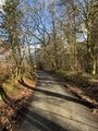
Although this path was clearer and decently easy to walk down, the ground had a lot of hidden water beneath it. I was able to avoid this by looking at the general landscape before stepping somewhere, meaning I could avoid the lower sections with the streams running through them. I eventually made it back to the path to a point that I had previously considered using to reach the point on the way there. Relieved, but also feeling a little bit silly for panicking, I began the journey back to the boat.
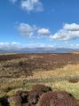
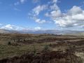
I stopped at a point I had passed earlier to take a photo of the loch. In this photo, you can see Ben Lomond and Inchmurrin, both of which featured in my 2024-03-22 56 -4 expedition. I kept walking down the path - which was much faster than the hike up - and eventually reached the boat again. The expedition took a total of about 2 hours and 40 minutes.
Photos
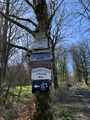
Sign pointing to the Shooting School

Reached the geohash

Zoomed out view
The geohash itself
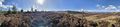
Panorama from the geohash

Bereal taken at the geohash point
Other side of the Bereal photo
West Dunbartonshire/Argyll and Bute boundary wall
View from the top of the hill with Ben Lomond and Inchmurrin
The path on the way back down
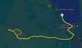
The route I took to the point and back
All of the 'off-road' section

Proof for the walk and climb achievements


Achievements
KerrMcF earned the Land geohash achievement
|
KerrMcF earned the Walk geohash Achievement
|
KerrMcF earned the One with Nature Geohash Achievement
|
KerrMcF earned the Large Climb achievement
|
Progress
| Council Area | Postcode | NUTS | Centicule |
|---|---|---|---|
| West Dunbartonshire | G(83) | UKM81 | 06 |
| Expedition Navigation | ||
|---|---|---|
| KerrMcF's expeditions | Next | |