2024-04-21 51 5
| Sun 21 Apr 2024 in 51,5: 51.2448582, 5.7472927 geohashing.info google osm bing/os kml crox |
Location
In a bit of forest near Weert.
Participants
Expedition 1:
- MyrtleGlacy
- MyrtleGlacy's girlfriend
Expedition
This hash looked like a fun one, and looking at it on the internet made it seem like it was a small wooded area with some paths through it. We had already borrowed a car, so for once there was no limit to what we could reach with public transport. It looked like it wouldn't rain, and we had all the time in the world, so we went for it.
Starting off at Tilburg Centraal, we made our way to a supermarket in Eindhoven to grab Road Trip snacks (and lunch). After getting some Autodrop, drinks and some croissants, we continued our way to Weert. We planned to drive to a restaurant to navigate further from there. We had to wait out some rain, and more rain was on its way, so we had to move fast. From the restaurant, we were very close to the hash, so we left the car and continued on foot.
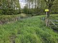
Walking along the road to the wooded area, the Kootspeel, we noticed that most of it was fenced off. There were also some small streams. Luckily, there was a gate letting us know that this was an area that was kept by Natuurmonumenten and that we were not allowed outside of the paths.
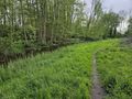
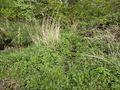
The path along the stream was pretty. Everything is clearly gearing up for spring, even if the temperature isn't there yet. After a bit, the path got very muddy. MyrtleGlacy had been an idiot going on this expedition and wore some good shoes. Well, they had to get dirty at some point, right?
We got close to the hash on the wrong side of the stream. MyrtleGlacy was already planning to wade through the wade to get to the hash, but the girlfriend showed more restraint and suggested we check for a bridge somewhere. Luckily, we found one. So crossing the bridge, we now had to double back and look for the hash again..... Right across the bridge, there were remains of an old building. We couldn't figure out what it could have been, a pigsty was our best bet.
We found out that there were more small streams. Nothing too bad, but just too big to jump over easily. At one point, we were within 9 meters of the hash, but still on the wrong side of the water. We looked around and about 30 meters ahead, there were two big branches across the water. One of them snapped when weight was placed on it, but was still holding 10 centimeter lower. There were two big branches above them as well, allowing MyrtleGlacy to lift himself a bit while walking across the branches.
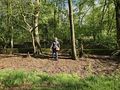
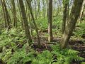
Finally on the right side of the water, a way was quickly made to the hash. GPS wouldn't get within a meter of the hash, but there was a stand of 4 trees that looked like a significant spot, so that seemed like as good a spot as any to take the pictures.
Going back, all the streams and paths seemed easier. Maybe because we know they were crossable or maybe because we were warmed up. Luckily, we made it back to the restaurant before further rain. Drank a quick cup of tea and some hot cocoa and drove back home.
Fun expedition, even if we got closer to nature than we had intended to when we started off.
Photos
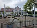
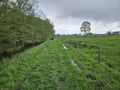
Good spot to park
Lucky this was there, otherwise there was no way to go in
I love these little forgotten paths
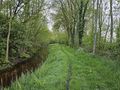
This path just kept following the stream
One wrong step and it's up to the ankle in mud
It doesn't look like much, but it goes across the water
She's a champ, coming with me like this
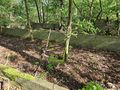
We couldn't figure out what this might have been. Pigsty?
Some sticks across the water is a bridge, right?
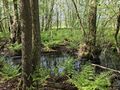
Within 9 meters, but wrong side of the water
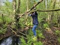
I don't think they would have held if the branches above weren't there
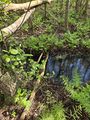
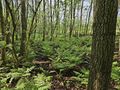
Within 2 meters, this looked like a Hash-worthy spot

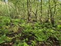
Hash reached!

I didn't forget for once!
Actually pretty nice...
...except for the mosquitoes, ticks and mud.


Achievements
In my quest to reach the Subdivision Achievement for the Dutch Provinces, this was Limburg.