2024-10-24 47 -122
| Thu 24 Oct 2024 in Seattle: 47.6518121, -122.3088788 geohashing.info google osm bing/os kml crox |
Location
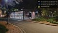
Either next to or atop a cement wall bordering vehicle access to a life sciences building on the UW campus
Participants
Plans
Expedition
- This is an honorable mention for Cubicle Geohash for me! I won't be around in the evening which is when I bet others will get to this hash, but I plan to be there about 3:30-4pm. -- Zebburkeconte (talk) 09:18, 24 October 2024 (PDT)
- My GPS accuracy is bad (because of the big concrete wall?). I went both below on the driveway and above in the shrubbery and never got a great reading. But I've surely been there! -- Zebburkeconte (talk) @47.6518,-122.3091 16:55, 24 October 2024 (PDT)
Thomcat
From Montlake Terrace and Bothell, I knew I didn't want to fight traffic to get there, and no firm plans were made. As I wrapped up a distracting task, I noticed it was getting pretty late, and a check of the this site didn't show any activity at the geohash point (weird, because there was!). At that point, I knew I had to drive down, to preserve the relatively easy hash.
My original plan was to light rail down there, but in the interest of time, I drove the few miles. Parking wasn't easy to find, but I eventually found something. A quick test snap shows that landscape photos are still the only ones to use. No time to debug that further now - could be my phone settings, the app, or a combination of those.
I didn't do any research ahead of time other than glancing at it being on a driveway. This turned out to be a descending driveway, with a large cement retaining wall keeping some plants several meters above it. No sign of previous visits, but then I didn't bring my chalk either. At the base of the wall, I found myself at around 5 meters south of the hashpoint, and vowed to do better.
Now is where the research would have helped a lot! A top the wall was a lot of vegetation, and beyond that a path which is more than 5 meters away. Being on the path was not at the hashpoint either, of course. I got close, then found a place to enter the path. A small campus bus and a campus security vehicle passed while I contemplated this, and I fully expected one to circle back and ask some questions.
Neither did. I bushwacked further in, reaching a point atop the wall. A thin chain link fence (and a steep drop) separated me from where I had been earlier - and now the hash point was 4.3 meters further south. Unless the wall was at a very noticeable angle, this would be impossible. A hash dance might have found a better satellite reception (lots of trees and vegetation), but at this point of the night, I was done.
Calling this a success, and will strive to have at least one a month - a definite achievement in the Seattle area, where at one point I documented more than 30 days in a row of water and no trespassing hashes. A monthly expedition, no problem. A monthly success? Down to luck.
Tracklog
Photos

In my cubicle

In my cubicle, with location :) @47.6546,-122.3118

At the hashpoint! @47.6518,-122.3091

Beautiful @47.6518,-122.3091

Proof

good to see the sideways issue still exists @47.6523,-122.3127

life sciences @47.6524,-122.3105

atop that? @47.6518,-122.3090

I can do better? @47.6518,-122.3089

top down @47.6518,-122.3089

test @47.6518,-122.3089
bike garage @47.6515,-122.3088


