2025-03-20 52 13
| Thu 20 Mar 2025 in 52,13: 52.4252670, 13.9126826 geohashing.info google osm bing/os kml crox |
Location
In the Hangelsberger Heide forest.
Participants
Plans
RE1 to Hangelsberg, hourly. Return train 38 minutes later. Either walk and spend 1h38, or bike and spend 38 minutes.
In my quest to hash in all subdivisions of Brandenburg, Oder-Spree has been surprisingly hard considering that it borders Berlin. It contains several large forests, so when I see points out this way they often look far from civilization. I even initially overlooked this point since Google Maps said it was unreachable by transit - apparently it considered a 45-minute walk a bit too long. So I was excited about heading to a national park point in 53,12 instead, until I figured out that the national park really doesn't want people going off trail, or even bikes going on the wrong trail.
Expedition
It's so warm in Berlin. I strip to a T-shirt while eating lunch on a sunny sidewalk. Next I engage in the stereotypically German errand of printing hardcopy tickets for all my weekend trip plans. I drop the printouts and a layer of clothes at home, then hurry to Ostkreuz. As I approach the station it's worryingly close to the departure time I expect, but I can't see the platform yet. Once I reach the platform I find the train is already there, so I jump on board.
Twenty-odd minutes later I'm in Hangelsberg. The train departs, the crossing gates go up, but then down again. I watch a lone Rail Force One locomotive thunder through in the same direction, then the gates let me proceed towards the forest.
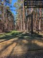
It's a fairly long walk on quite a variety of path surfaces. A duo on e-bikes passes me. A bird of prey circles. Butterflies flit about the path - most yellow (Google Lens: Gonepteryx rhamni), a couple orange and black (Google Lens: Polygonia c-album). Undergrowth varies from grass to dead ferns to brambles.
With 50 meters to go, I find I do have to negotiate a few brambles to leave the path, and apologize to my pants. Some stumbling through mossy ground ensues, then I'm in the desired location. I turn back and am surprised at how quickly I regain the path. When I look down to clear any lingering thorns from my ankles, I see something on my shoe - must be a tick. I use a fallen cone to brush it off.
For the walk back, I choose a different route for variety. There's a fenced area I'll have to map in OSM. I estimate I'll be cutting it close again and ask my legs to pick up the pace, but nothing really changes. An official-looking car passes me. Just before I turn onto the main road, I hear the crossing gates go down. When I reach the platform, I can see the train in the distance, and within a minute it's there. Near Ostkreuz I prioritize finding hydration and energy. Further tick checks find no others.
Tracklog
Photos

Path junction @52.4077,13.9128
Another path junction @52.4162,13.9098

Geohasher @52.4253,13.9127

Map screenshot

Dermacentor reticulatus, probably? @52.4251,13.9135


Achievements
coyotebush earned the Public transport geohash achievement
|