This page details my cross-continent trip, which has little to do with geohashing, other than my relocation to a much better graticule.
Contents
[hide]2009-08-28
Beginning of day 1. tracklog kml
Pre Mission Mile 0
I had my apartment ransacked and packed my bags. I then went to work, and said my farewells for a couple hours before heading home. I then packed up the car, got myself coated in sweat, and turned in the keys to my apartment. We stopped to get gas and got on the road at about 2:30 PM or so.
Mission Mile 30
I had to call into a meeting for work, and proceeded to continue with this call until the next milestone.
Mission Mile 100
I had just gotten off the phone, and looked over at the console (my mom had been driving since I had to call in to the meeting), and saw the "Service Engine Soon" light was on. We proceeded to get off at the next exit so we could read the manual, and check some vitals of the vehicle, and ensured the gas cap was tight. Everything checked out to be OK, but the light was still on, and we couldn't find a service station nearby, so we proceeded down the highway a bit until we could find a service station. I then called my dad to get his advice, and he also suggested that we try to stop at a service station (it was now about 4:30 PM on a friday, so chances were slim).
Mission Mile 110
We got off on the exit to Vero Beach, Florida, and proceeded to Bobby's Auto Repair (Thank you garmin). The kind attendant there hooked the car up to the analyzation box, and determined that it was an oxygen sensor, and told us the car should be perfectly fine for the rest of the 4000 mile journey to Oregon. Huzzah! We switched drivers (to me driving), and continued on our way.
Mission Mile 200
We passed through a rain storm. (Of course when I am driving). It lasted about 10 minutes.
Mission Mile 260
End of day 1. We stopped at the Best Western in Palm Coast, Florida. We check in, and then go to Steak and Shake for dinner where I have a tasty frisco melt, cheese fries, and a mocha shake. Refuel.
Photos
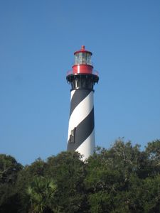
St. Augustine lighthouse
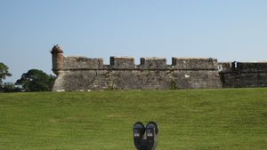
Castillo de San Marcos


2009-08-29
Beginning of day 2. tracklog kml
Mission Mile 300
We arrived at Castillo de San Marcos in St. Augustine, Florida. We took some pictures of the fort and the nearby lighthouse from the parking lot before continuing on to Savannah.
Mission Mile 470-480
Savannah, Georgia. We ate at Sweet Potatoes, where I had a pot roast with garlic mashed potatoes, which was very delicious. We then proceeded to refuel, and drive to the historic downtown. We stopped at the Cathedral of St. John the Baptist, and walked through a few of the squares (parks) and through a couple of the old streets with historic houses. We then drove down to the waterfront, and along the main road by the water. We got lost in trying to leave the city. The GPS was being annoyingly difficult, so I pulled over in an abandoned parking lot until we got things sorted out.
Mission Mile 560
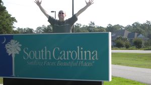
We stopped at a roadside shop specializing in ciders, sweetgrass baskets, and other Carolina-centric stuffs. We purchased some grape cider and chocolate coated pecans.
Mission Mile 600
We stopped in Charleston, South Carolina for a little while, looking at the coast, Fort Sumter, and the historic downtown. We walked and drove along various of the narrow downtown streets, looking at all the old houses.
Mission Mile 655
End of day 2. We end our day in Georgetown, South Carolina. We ate at a place called Dock House Tavern. The food was average, but huge portions.
Photos
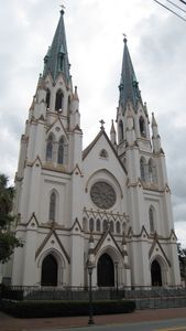
St. John the Baptist Cathedral
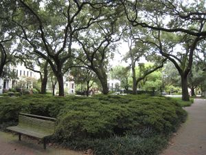
Pulaski Square


2009-08-30
Beginning of day 3. tracklog kml
Got to about 1.2 km away from this hashpoint.
Mission Mile 700
Refuel in North Myrtle Beach, South Carolina.
Mission Mile 950
Visit the outer banks of North Carolina at Atlantic Beach, and Beaufort. Ate a delicious lunch at the Beaufort Grocery Co. I ate two chicken salad on Parmesan pastry rolls with sides of mixed fruit and sweet potato chips. Changed pace from steady to grueling.
Mission Mile 1000
Driving on US 70, 5 miles north of Kinston, North Carolina at Foss Metals junkyard/recyclers, 4:24 PM US Eastern Daylight Savings time.
Mission Mile 1155
End of day 3. Ate at Tripp's Restaurant and Tavern in Greensboro, North Carolina. I had a 3-cheese burger, which was quite average.
Photos
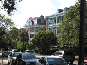
Charleston, SC
SC/NC border


2009-08-31
Mission Mile 1155
refuel. Begin driving in North Carolina, in the rain, during rush hour. Passing through Virginia, into West Virginia.
Mission Mile 1425
Lunch at O'Charley's restaurant in Huntington, West Virginia. I had a buffalo chicken sandwich. Refuel and driver change.
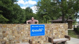
Mission Mile 1735
Passing through Kentucky, taking a bit of a scenic US highway drive on the way, refueling outside Evansville, Indiana.
Mission Mile 1875
End of day 4. Went to the Hen House for dinner, where I had a poor quality cheeseburger. Spending the night outside Okawville, Illinois, which I can only describe as a dozen houses in the middle of a large field. refuel.
Photos
WV/KY border
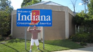
KY/IN border


2009-09-01
Got to about 1.3 km away from this hashpoint.
Mission Mile 1920
Drove by the St. Louis gateway arch.
Mission Mile 2000
About 4.5 miles past Danville, Missouri at 9:38 AM. I-70 mile marker 166.0.
Mission Mile 2160
Lunch at LC's BBQ in Kansas City, Missouri. I had a very delicious sliced pork sandwich with fries. refuel.
Mission Mile 2340
Refuel near Salina, Kansas.
Mission Mile 2580
End of day 5. Went to Crazy R's in Goodland, Kansas. I ate a KC strip steak with a baked potato. It was good, but not for the price. Then went to Dairy Queen to get a Heath Blizzard. refuel.
Photos
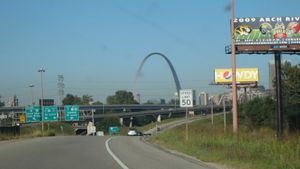
Gateway Arch
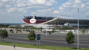
Arrowhead Stadium


2009-09-02
Got to about 1.45km away from this hashpoint.
Hash colision! This hashpoint landed in the median strip of the highway I was taking, less than .1km away! Expedition report.
Mission Mile 2800
Lunch at Echo Lake Lodge (10600 ft elev.). I had a good order of fish and chips. Alkaline water (my mom got a bad glass of diet Coke).
Mission Mile 2840
Refuel in Idaho Springs, Colorado
Mission Mile 3000 (retroactive)
About 1 mile west of Rifle, Colorado. Approximately at mile marker 89 on I-70. Reached about 2:45 pm mountain time.
Mission Mile 3030
Realized that I missed the turnover at 3000 miles, and figured out where and what time it would have ticked over. No water.
Mission Mile 3058
Refuel in Grand Junction, Colorado. (And rewater)
Mission Mile 3090
After driving in Utah for no more than a mile, I hit a tumbleweed. This does not bode well for my luck in this state. No damage to the car, probably lots of damage to the tumbleweed, since I discovered at my next stop that a piece of it was stuck in my front bumper.
Mission Mile 3120-3150
Turned onto a very scenic drive along Utah highway 128. It traveled along the Colorado river, through a couple of its spectacular gorges and canyons.
Mission Mile 3150-3200
Driving in Arches National Park, and pulling over at the many lookout points to look at the natural sandstone formations which litter the area.
Mission Mile 3200
Pulled into the wrong Best Western in Moab, Utah.
Mission Mile 3200
End of day 6. Pulled into the correct Best Western in Moab, Utah. Ate at Pasta Joe's, where I had Cheese Tortellone Alfredo with Chicken and garlic bread. It was a delicious dinner. Joe is exhausted. Do you: 1) Continue as normal 2) Reduce pace, and continue 3) Stop to rest.
Photos
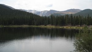
Echo Lake, CO
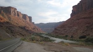
Colorado River, near Moab, UT


2009-09-03
Got about 1km away from this hashpoint.
Mission Mile 3200-3250
refuel. Option 2 chosen. More Arches National Park, including landscape arch.
Mission Mile 3360
Lunch in Price, Utah at Big Moe's. I had a decent kielbasa, and an oatmeal raisin cookie. No water.
Mission Mile 3370
Joe is dehydrated.
Mission Mile 3500
Stop at Great Salt Lake State Marina near Salt Lake City, Utah. Fresh Water. Joe is only moderately dehydrated.
Mission Mile 3510
refuel in Salt Lake City. Drive by the temple square, and take a few pictures.
Mission Mile 3600
End of day 7. Ate at El Perral in Tremonton, Utah, where I had a very good cheese enchilada, chicken taco, spanish rice, and refried beans. Joe is exhausted.
Photos
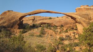
Landscape Arch
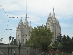
Salt Lake Temple


2009-09-04
Mission Mile 3700
Turned off of the interstate to take a scenic road through Twin Falls, Idaho and surrounding towns. The road was mostly through fields and cow pastures, but occasionally I would get a fantastic view of the Snake River valley.
Mission Mile 3970
Finally in Oregon! Lunch in Ontario, Oregon at Arby's, because all local places we found seemed to be much more of dives than I felt like at the time.
Mission Mile 4000
On I-84 in Oregon at about mile marker 320, which is about 2 miles east of Pleasant Valley, at 1:34 pacific time.
Mission Mile 4015
Stopped in Baker City to have a nice person in Oregon pump my gas for me (it is illegal in Oregon to pump gasoline unless you are certified to do so, and currently on the clock at a gas station). Started on state and US highways along a scenic byway towards John Day
Mission Mile 4100
End of day 8. Took a short walk through downtown John Day, Oregon (population ~2000). Not much to see, a couple restaurants, and a dozen or so shops. Dinner at Squeeze-In Restaurant, where I had average chicken strips, baked potato, corn, and toast.
Photos

UT/ID border
ID/OR border


2009-09-05
Mission Mile 4100
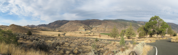
Driving along the scenic John Day River valley, near the John Day Fossil Beds National Monument. Very pretty gorges, hills, canyons, etc. all through this area.
Mission Mile 4290
Have my car refueled for me in Madras, Oregon.
Mission Mile 4350
Driving along the highway near Timberline Lodge at Mount Hood. Of course I am driving, and it is yet again raining. Why did it happen that I was always the one driving in the mountains in the rain?
Mission Mile 4425
You have completed the Oregon Trail! End of day 9. Late lunch at Marie Callendar's, where I had an extremely delicious chicken pot pie. I also had a slice of mocha cream cheese pie. I finally get to sleep in my own bed! Wait, crap, my furniture doesn't get delivered for another 4 days. =(
Photos
John Day Fossil Beds National Monument

Addendum
Cumulative tracklog (warning, long to load) kml
All in all, the trip was extremely awesome! I had a great time, and saw a whole lot of the country I have only seen from an airliner's window before. And also saw some stuff that I likely have never even seen from an airliner window as well. We also took an excursion to the Oregon coast, including Astoria, Seaside, Cannon Beach, and Tillamook, on 2009-09-07. I decided that it is inappropriate to post all of the pictures on the wiki, when my trip had basically nothing to do with geohashing, other than that I moved to a new graticule. I did decide, however, that I will post 2 pictures from each day, including to the coast. The rest of the pictures can be located here: http://www.facebook.com/home.php#/aperfectring?v=photos&ref=name
Geohashing count. I got within 1 mile (1.6km) of five hashpoints, one of which was under 0.1km away.
Oregon Coast Photos
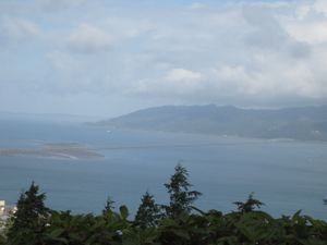
Columbia River at Astoria, OR
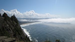
Pacific Ocean on the Oregon coast.

