Difference between revisions of "2024-04-21 65 25"
From Geohashing
m (Location) |
m (subst-ing) |
||
| Line 1: | Line 1: | ||
{{meetup graticule | {{meetup graticule | ||
| − | | lat= | + | | lat=65 |
| − | | lon= | + | | lon=25 |
| − | | date= | + | | date=2024-04-21 |
}} | }} | ||
== Location == | == Location == | ||
| Line 34: | Line 34: | ||
{{Land geohash | {{Land geohash | ||
| name=[[User:Kripakko|Kripakko]] | | name=[[User:Kripakko|Kripakko]] | ||
| − | | latitude= | + | | latitude=65 |
| − | | longitude= | + | | longitude=25 |
| − | | date= | + | | date=2024-04-21 |
}} | }} | ||
{{Frozen geohash | {{Frozen geohash | ||
| name=[[User:Kripakko|Kripakko]] | | name=[[User:Kripakko|Kripakko]] | ||
| − | | latitude= | + | | latitude=65 |
| − | | longitude= | + | | longitude=25 |
| − | | date= | + | | date=2024-04-21 |
| temperature=−2 °C | | temperature=−2 °C | ||
}} | }} | ||
Latest revision as of 21:19, 24 May 2024
| Sun 21 Apr 2024 in 65,25: 65.2448582, 25.7472927 geohashing.info google osm bing/os kml crox |
Location
In a forest near Iso Lavalampi pond, Haukipudas, Oulu.
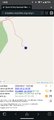
The point on a topographic map: [1]
Participants
Expedition
I drove to the hashpoint, and this time I attempted filming the expedition using an action camera that I set up as a dashcam. The video did not turn out too great, but here it is, minimally edited. If you do not feel like watching me driving and listening to a Finnish radio channel, feel free to skip ahead to about 38 minutes when I get near the hashpoint.
Expedition video
Tracklog
Photos
Proof of location and time, screenshot of QDGN.
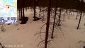
How the hashpoint looked like, snapshot of the video.


Achievements
Kripakko earned the Land geohash achievement
|

Kripakko earned the Frozen Geohash Achievement
by reaching the (65, 25) geohash on 2024-04-21 while the temperature was −2 °C.