Difference between revisions of "2024-06-03 46 -71"
([live picture]The field [https://openstreetmap.org/?mlat=46.76522500&mlon=-71.11020278&zoom=16 @46.7652,-71.1102]) |
|||
| Line 10: | Line 10: | ||
== Location == | == Location == | ||
<!-- where you've surveyed the hash to be --> | <!-- where you've surveyed the hash to be --> | ||
| + | In a field, on the side of Harlaka bike path in Pintendre. | ||
== Participants == | == Participants == | ||
<!-- who attended: If you link to your wiki user name in this section, your expedition will be picked up by the various statistics generated for geohashing. You may use three tildes ~ as a shortcut to automatically insert the user signature of the account you are editing with. | <!-- who attended: If you link to your wiki user name in this section, your expedition will be picked up by the various statistics generated for geohashing. You may use three tildes ~ as a shortcut to automatically insert the user signature of the account you are editing with. | ||
--> | --> | ||
| + | * [[User:Gict|Gict]] | ||
| + | * Gict's boyfriend | ||
== Plans == | == Plans == | ||
<!-- what were the original plans --> | <!-- what were the original plans --> | ||
| + | To go after work and appointments but before groceries. I will make it an excuse to go biking. | ||
== Expedition == | == Expedition == | ||
<!-- how it all turned out. your narrative goes here. --> | <!-- how it all turned out. your narrative goes here. --> | ||
| + | The hashpoint is pretty much on the same bike path as the last hash I attempted. So we parked at the same parking than last time in Saint-Henri. We had a parking choice closer to the coordinates but it will be only 2,4km of bike. I wouldn't have taken the bikes out for that. The boyfriend was also happy to ride. From the parking, we headed north for a planned 8,5km. | ||
| + | |||
| + | The path is straight all the way. The elevation is essentially flat all the way too; only one train track to cross on a bridge. There was front wind but nothing else worth mentioning. | ||
| + | |||
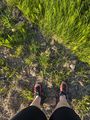
| + | I stopped at the mark I had seen on the satellite image. It was 7 pm. I walked across the ditch by a tractor access. The boyfriend was waiting, holding the bikes while I took my pictures. | ||
| + | |||
| + | The way back was similar except we hit the smell of a piggery. | ||
| + | |||
| + | There was an ice cream shop next to where the car was. I would have liked a slushy. But the cash-only sign put us on our way. We add groceries to get anyway. | ||
== Tracklog == | == Tracklog == | ||
<!-- if your GPS device keeps a log, you may use Template:Tracklog, post a link here, or both --> | <!-- if your GPS device keeps a log, you may use Template:Tracklog, post a link here, or both --> | ||
| + | {{tracklog|2024-06-03 46 -71 Gict Tracklog.gpx}} | ||
== Photos == | == Photos == | ||
| Line 29: | Line 43: | ||
--> | --> | ||
<gallery perrow="5"> | <gallery perrow="5"> | ||
| − | + | Image:2024-06-03_46_-71_Gict_1717455815133.jpg|Proof | |
| − | Image:2024-06-03_46_-71_Gict_1717455815133.jpg| | ||
| − | |||
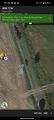
Image:2024-06-03_46_-71_Gict_1717457516747.jpg|The field [https://openstreetmap.org/?mlat=46.76522500&mlon=-71.11020278&zoom=16 @46.7652,-71.1102] | Image:2024-06-03_46_-71_Gict_1717457516747.jpg|The field [https://openstreetmap.org/?mlat=46.76522500&mlon=-71.11020278&zoom=16 @46.7652,-71.1102] | ||
| + | Image:2024-06-03_46_-71_gict_The_haspoint.jpg|The haspoint | ||
| + | Image:2024-06-03_46_-71_gict_The_view.jpg|The view | ||
| + | Image:2024-06-03_46_-71_gict_The_ditch_the_bikes_my_shadow.jpg|Ditch, bikes, shadow | ||
</gallery> | </gallery> | ||
| Line 38: | Line 53: | ||
{{#vardefine:ribbonwidth|100%}} | {{#vardefine:ribbonwidth|100%}} | ||
<!-- Add any achievement ribbons you earned below, or remove this section --> | <!-- Add any achievement ribbons you earned below, or remove this section --> | ||
| + | {{land geohash | latitude = 46 | longitude = -71 | date = 2024-06-03 | name = Gict }} | ||
| + | |||
__NOTOC__ | __NOTOC__ | ||
| − | |||
| − | |||
| − | |||
| − | |||
| − | |||
| − | |||
| − | |||
| − | |||
| − | |||
| − | |||
[[Category:Expeditions]] | [[Category:Expeditions]] | ||
| − | |||
[[Category:Expeditions with photos]] | [[Category:Expeditions with photos]] | ||
| − | |||
| − | |||
| − | |||
| − | |||
[[Category:Coordinates reached]] | [[Category:Coordinates reached]] | ||
| − | |||
| − | |||
| − | |||
| − | |||
| − | |||
| − | |||
| − | |||
| − | |||
| − | |||
| − | |||
| − | |||
| − | |||
| − | |||
| − | |||
Revision as of 19:41, 4 June 2024
| Mon 3 Jun 2024 in 46,-71: 46.7651490, -71.1103475 geohashing.info google osm bing/os kml crox |
Location
In a field, on the side of Harlaka bike path in Pintendre.
Participants
- Gict
- Gict's boyfriend
Plans
To go after work and appointments but before groceries. I will make it an excuse to go biking.
Expedition
The hashpoint is pretty much on the same bike path as the last hash I attempted. So we parked at the same parking than last time in Saint-Henri. We had a parking choice closer to the coordinates but it will be only 2,4km of bike. I wouldn't have taken the bikes out for that. The boyfriend was also happy to ride. From the parking, we headed north for a planned 8,5km.
The path is straight all the way. The elevation is essentially flat all the way too; only one train track to cross on a bridge. There was front wind but nothing else worth mentioning.
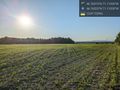
I stopped at the mark I had seen on the satellite image. It was 7 pm. I walked across the ditch by a tractor access. The boyfriend was waiting, holding the bikes while I took my pictures.
The way back was similar except we hit the smell of a piggery.
There was an ice cream shop next to where the car was. I would have liked a slushy. But the cash-only sign put us on our way. We add groceries to get anyway.
Tracklog
Photos
Proof
The field @46.7652,-71.1102
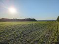
The haspoint
The view
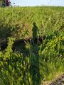
Ditch, bikes, shadow


Achievements
Gict earned the Land geohash achievement
|