| Mon 3 Jun 2024 in 46,-71: 46.7651490, -71.1103475 geohashing.info google osm bing/os kml crox |
Location
In a field, on the side of Harlaka bike path in Pintendre.
Participants
- Gict
- Gict's boyfriend
Plans
To go after work and appointments but before groceries. I will make it an excuse to go biking.
Expedition
The hashpoint is pretty much on the same bike path as the last hash I attempted. So we parked at the same parking than last time in Saint-Henri. We had a parking choice closer to the coordinates but it will be only 2,4km of bike. I wouldn't have taken the bikes out for that. The boyfriend was also happy to ride. From the parking, we headed north for a planned 8,5km.
The path is straight all the way. The elevation is essentially flat all the way too; only one train track to cross on a bridge. There was front wind but nothing else worth mentioning.
I stopped at the mark I had seen on the satellite image. It was 7 pm. I walked across the ditch by a tractor access. The boyfriend was waiting, holding the bikes while I took my pictures.
The way back was similar except we hit the smell of a piggery.
There was an ice cream shop next to where the car was. I would have liked a slushy. But the cash-only sign put us on our way. We add groceries to get anyway.
Tracklog
Photos
Proof
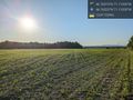
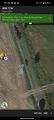
The field @46.7652,-71.1102
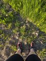
The haspoint
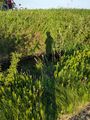
Ditch, bikes, shadow


Achievements
Gict earned the Land geohash achievement
|