Difference between revisions of "2024-06-27 65 25"
(Created page with "{{subst:expedition}}") |
m (Location) |
||
| (One intermediate revision by one other user not shown) | |||
| Line 1: | Line 1: | ||
| − | + | {{meetup graticule|date=2024-06-27|lat=65|lon=25}} | |
| − | |||
| − | |||
| − | |||
| − | |||
| − | |||
| − | |||
| − | |||
| − | |||
== Location == | == Location == | ||
| − | + | On a road next to the Linnanmaa campus of the University of Oulu. | |
== Participants == | == Participants == | ||
| − | + | * [[User:Kripakko|Kripakko]] | |
| − | |||
| − | |||
| − | |||
| − | |||
== Expedition == | == Expedition == | ||
| − | + | Finally, some doable coordinates! | |
| + | I could easily cycle there after work. | ||
| + | The weather was absolutely lovely: sunny and about 21 °C, so not yet too hot. | ||
| + | I made my way through the city to Linnanmaa, stopped a few times to take photos and reached the hashpoint without any difficulty. | ||
| + | Since the point is close to the big campus of the University of Oulu | ||
| + | ([https://www.oulu.fi/en Website], [https://en.wikipedia.org/wiki/University_of_Oulu Wikipedia]), | ||
| + | for most of the year it would be swarming with students, but in a summer evening it was totally silent. | ||
| + | I could stand around the hashpoint without having to mind traffic, but still I tried to be quick to leave. | ||
| + | Then, I cycled home via the nearby Prisma megastore and the city centre. | ||
| + | Pretty much nothing interesting happened. | ||
| + | I determined later that I cycled 20.2 kilometres during the trip. | ||
== Tracklog == | == Tracklog == | ||
| − | + | {{tracklog|2024-06-27_65_25_tracklog.gpx}} | |
== Photos == | == Photos == | ||
| − | |||
| − | |||
| − | |||
<gallery perrow="5"> | <gallery perrow="5"> | ||
| + | Image:2024-06-27_65_25_01-river.jpg| The Oulujoki river. | ||
| + | Image:2024-06-27_65_25_02-campus1.jpg| Some buildings of the university campus, mixing brutalist concrete and bright colours. | ||
| + | Image:2024-06-27_65_25_03-campus2.jpg| More buildings of the university campus. | ||
| + | Image:2024-06-27_65_25_04-qdgn.png| Proof of location and time, screenshot of [https://kripakko.neocities.org/qdgn QDGN]. | ||
| + | Image:2024-06-27_65_25_05-selfie.jpg| Stupid Grin™ | ||
</gallery> | </gallery> | ||
== Achievements == | == Achievements == | ||
| − | {{ | + | {{land geohash |
| − | + | | name = [[User:Kripakko|Kripakko]] | |
| + | | latitude = 65 | longitude = 25 | date = 2024-06-27 | ||
| + | }} | ||
| + | {{bicycle geohash | ||
| + | | name = [[User:Kripakko|Kripakko]] | distance = 20.2 km | ||
| + | | latitude = 65 | longitude = 25 | date = 2024-06-27 | ||
| + | }} | ||
__NOTOC__ | __NOTOC__ | ||
| − | |||
| − | |||
| − | |||
| − | |||
| − | |||
| − | |||
| − | |||
| − | |||
| − | |||
[[Category:Expeditions]] | [[Category:Expeditions]] | ||
| − | |||
[[Category:Expeditions with photos]] | [[Category:Expeditions with photos]] | ||
| − | |||
| − | |||
| − | |||
| − | |||
[[Category:Coordinates reached]] | [[Category:Coordinates reached]] | ||
| − | + | {{location|FI|14}} | |
| − | |||
| − | |||
| − | |||
| − | |||
| − | |||
| − | |||
| − | |||
| − | |||
| − | |||
| − | |||
| − | |||
| − | |||
| − | |||
Latest revision as of 21:42, 27 June 2024
| Thu 27 Jun 2024 in 65,25: 65.0574982, 25.4620776 geohashing.info google osm bing/os kml crox |
Location
On a road next to the Linnanmaa campus of the University of Oulu.
Participants
Expedition
Finally, some doable coordinates! I could easily cycle there after work. The weather was absolutely lovely: sunny and about 21 °C, so not yet too hot. I made my way through the city to Linnanmaa, stopped a few times to take photos and reached the hashpoint without any difficulty. Since the point is close to the big campus of the University of Oulu (Website, Wikipedia), for most of the year it would be swarming with students, but in a summer evening it was totally silent. I could stand around the hashpoint without having to mind traffic, but still I tried to be quick to leave. Then, I cycled home via the nearby Prisma megastore and the city centre. Pretty much nothing interesting happened. I determined later that I cycled 20.2 kilometres during the trip.
Tracklog
Photos
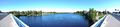
The Oulujoki river.
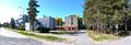
Some buildings of the university campus, mixing brutalist concrete and bright colours.
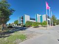
More buildings of the university campus.
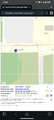
Proof of location and time, screenshot of QDGN.
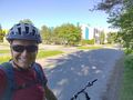
Stupid Grin™


Achievements
Kripakko earned the Land geohash achievement
|
Kripakko earned the Bicycle geohash achievement
|