Difference between revisions of "2024-06-29 58 5"
From Geohashing
(→Achievements) |
|||
| (14 intermediate revisions by the same user not shown) | |||
| Line 9: | Line 9: | ||
-->{{meetup graticule|date=2024-06-29|lat=58|lon=5}} | -->{{meetup graticule|date=2024-06-29|lat=58|lon=5}} | ||
| − | [[Image: | + | [[Image:20240629_Me.jpg|thumb|left]] |
== Location == | == Location == | ||
<!-- where you've surveyed the hash to be --> | <!-- where you've surveyed the hash to be --> | ||
| Line 26: | Line 26: | ||
== Expedition == | == Expedition == | ||
<!-- how it all turned out. your narrative goes here. --> | <!-- how it all turned out. your narrative goes here. --> | ||
| + | |||
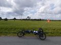
| + | Then there finally came a day when it was appropriate to have a bike ride to find a geohash. It fit well with the zero point on the cycle path and I used the opportunity to stretch my legs a bit. The trip was a total of 39.13 km. | ||
== Tracklog == | == Tracklog == | ||
| Line 37: | Line 39: | ||
Image:2024-06-29_58_5_Pica42_1719668800953.jpg|Sola [https://openstreetmap.org/?mlat=58.90301680&mlon=5.61332330&zoom=16 @58.9030,5.6133] | Image:2024-06-29_58_5_Pica42_1719668800953.jpg|Sola [https://openstreetmap.org/?mlat=58.90301680&mlon=5.61332330&zoom=16 @58.9030,5.6133] | ||
| + | Image:20240629 58 5 W.jpg|thumb|View to the west | ||
| + | Image:20240629_58 5 S.jpg|thumb|View to the south | ||
| + | Image:20240629 58 5 E.jpg|thumb|View to the east | ||
| + | Image:20240629_58 5 N.jpg|thumb|View to the north | ||
</gallery> | </gallery> | ||
| Line 43: | Line 49: | ||
<!-- Add any achievement ribbons you earned below, or remove this section --> | <!-- Add any achievement ribbons you earned below, or remove this section --> | ||
| − | + | {{land geohash |name=[[User:Pica42|Pica42]] |date=2024-06-29 |latitude=58 |longitude=5 }} | |
| − | |||
| − | |||
| − | [[ | ||
| − | |||
| − | |||
| − | |||
| − | |||
| − | |||
| − | |||
| − | |||
[[Category:Expeditions]] | [[Category:Expeditions]] | ||
| − | |||
[[Category:Expeditions with photos]] | [[Category:Expeditions with photos]] | ||
| − | |||
| − | |||
| − | |||
| − | |||
[[Category:Coordinates reached]] | [[Category:Coordinates reached]] | ||
| + | {{location|NO|11}} | ||
| − | -- | + | {{Bicycle geohash | latitude = 58 | longitude = 5 | date = 2024-06-29 | name = Pica42 }} |
| − | |||
| − | |||
| − | |||
| − | |||
| − | + | __NOTOC__ | |
| − | |||
| − | |||
| − | |||
| − | |||
| − | |||
| − | |||
Latest revision as of 17:55, 29 June 2024
| Sat 29 Jun 2024 in 58,5: 58.9030150, 5.6133894 geohashing.info google osm bing/os kml crox |

Location
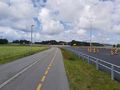
On a cycle path by the road between Sola and Tananger, Rogaland, Norway.
Participants
Plans
Expedition
Then there finally came a day when it was appropriate to have a bike ride to find a geohash. It fit well with the zero point on the cycle path and I used the opportunity to stretch my legs a bit. The trip was a total of 39.13 km.
Tracklog
Photos
Sola @58.9030,5.6133
View to the west
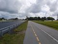
View to the south
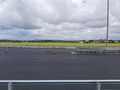
View to the east
View to the north


Achievements
Pica42 earned the Land geohash achievement
|
Pica42 earned the Bicycle geohash achievement
|