Difference between revisions of "2024-07-07 47 16"
Coyotebush (talk | contribs) (Created page with "{{subst:Expedition2}}") |
m (Location) |
||
| (8 intermediate revisions by one other user not shown) | |||
| Line 7: | Line 7: | ||
{{meetup graticule|date=2024-07-07|lat=47|lon=16}} | {{meetup graticule|date=2024-07-07|lat=47|lon=16}} | ||
== Location == | == Location == | ||
| + | |||
| + | Behind the Schmutterer market in Reisenberg. | ||
== Participants == | == Participants == | ||
| − | *[[User:Coyotebush| | + | *[[User:Coyotebush|coyotebush]] |
== Plans == | == Plans == | ||
| + | S-Bahn to Gramatneusiedl, then bike. (There is bus service to Reisenberg, but not on Sundays.) Time flexible. | ||
== Expedition == | == Expedition == | ||
| + | In the morning I loaded some BBBikes maps onto my Garmin bike computer and mounted it on my new Brompton. At Wien Hbf I bought a mobile ticket to supplement my local pass and boarded an S60 train once it arrived - start of the line, so it didn't get moving for quite a few more minutes. | ||
| + | |||
| + | *Boarded an S60 with a bike and a ticket for the section past the Vienna core zone. -- [[User:Coyotebush|Coyotebush]] ([[User talk:Coyotebush|talk]]) [https://openstreetmap.org/?mlat=48.18453830&mlon=16.37672403&zoom=16 @48.1845,16.3767] 10:15, 7 July 2024 (GMT+02:00) | ||
| + | |||
| + | I let Garmin navigate the way from Gramatneuseidl. Very intermittent bike paths in the towns. On the road between, a car driver slowed while passing me to (I think) point out the nice adjacent bike path; I saw a sign about the bike path project so it's likely new. | ||
| + | The market, path beside, and rubble behind were as expected. Took photos and retraced the route, except using the full length of the bike path. Then I found that the elevator to the northbound train platform was out of service (had seen a notice to this effect when buying the ticket), so got to practice carrying the Brompton down stairs. | ||
| + | |||
| + | == Tracklog == | ||
| + | {{tracklog|2024-07-07 47 16 coyotebush bike.gpx}} | ||
== Photos == | == Photos == | ||
| Line 25: | Line 37: | ||
<gallery perrow="5"> | <gallery perrow="5"> | ||
| + | |||
| + | Image:2024-07-07_47_16_coyotebush_1720343683116.jpg|Path alongside road [https://openstreetmap.org/?mlat=48.01587500&mlon=16.50871944&zoom=16 @48.0159,16.5087] | ||
| + | |||
| + | Image:2024-07-07_47_16_coyotebush_1720343715326.jpg|Market closed but EV charging [https://openstreetmap.org/?mlat=47.99933611&mlon=16.52024444&zoom=16 @47.9993,16.5202] | ||
| + | |||
| + | Image:2024-07-07_47_16_coyotebush_1720343734666.jpg|Hasher [https://openstreetmap.org/?mlat=47.99648056&mlon=16.52918611&zoom=16 @47.9965,16.5292] | ||
| + | |||
| + | Image:2024-07-07_47_16_coyotebush_1720343767533.jpg|Bike [https://openstreetmap.org/?mlat=47.99648056&mlon=16.52918611&zoom=16 @47.9965,16.5292] | ||
| + | |||
| + | Image:2024-07-07_47_16_coyotebush_1720343782921.jpg|Map | ||
</gallery> | </gallery> | ||
| Line 30: | Line 52: | ||
== Achievements == | == Achievements == | ||
{{#vardefine:ribbonwidth|100%}} | {{#vardefine:ribbonwidth|100%}} | ||
| + | |||
| + | {{Public transport geohash | ||
| + | |||
| + | | latitude = 47 | ||
| + | | longitude = 16 | ||
| + | | date = 2024-07-07 | ||
| + | | busline = the S60 train | ||
| + | | name = coyotebush | ||
| + | |||
| + | }} | ||
__NOTOC__ | __NOTOC__ | ||
| − | |||
| − | |||
| − | |||
[[Category:Expeditions]] | [[Category:Expeditions]] | ||
| Line 41: | Line 70: | ||
[[Category:Coordinates reached]] | [[Category:Coordinates reached]] | ||
| − | + | {{location|AT|NÖ|BN}} | |
| − | |||
| − | |||
| − | |||
| − | |||
| − | |||
| − | |||
| − | |||
Latest revision as of 16:42, 7 July 2024
| Sun 7 Jul 2024 in 47,16: 47.9964317, 16.5292088 geohashing.info google osm bing/os kml crox |
Location
Behind the Schmutterer market in Reisenberg.
Participants
Plans
S-Bahn to Gramatneusiedl, then bike. (There is bus service to Reisenberg, but not on Sundays.) Time flexible.
Expedition
In the morning I loaded some BBBikes maps onto my Garmin bike computer and mounted it on my new Brompton. At Wien Hbf I bought a mobile ticket to supplement my local pass and boarded an S60 train once it arrived - start of the line, so it didn't get moving for quite a few more minutes.
- Boarded an S60 with a bike and a ticket for the section past the Vienna core zone. -- Coyotebush (talk) @48.1845,16.3767 10:15, 7 July 2024 (GMT+02:00)
I let Garmin navigate the way from Gramatneuseidl. Very intermittent bike paths in the towns. On the road between, a car driver slowed while passing me to (I think) point out the nice adjacent bike path; I saw a sign about the bike path project so it's likely new.
The market, path beside, and rubble behind were as expected. Took photos and retraced the route, except using the full length of the bike path. Then I found that the elevator to the northbound train platform was out of service (had seen a notice to this effect when buying the ticket), so got to practice carrying the Brompton down stairs.
Tracklog
Photos
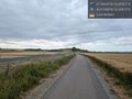
Path alongside road @48.0159,16.5087
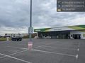
Market closed but EV charging @47.9993,16.5202
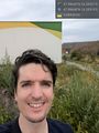
Hasher @47.9965,16.5292
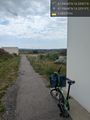
Bike @47.9965,16.5292
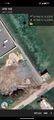
Map


Achievements
coyotebush earned the Public transport geohash achievement
|