Difference between revisions of "2024-07-07 48 9"
(→Tracklog) |
m (Location) |
||
| (6 intermediate revisions by one other user not shown) | |||
| Line 15: | Line 15: | ||
== Plans == | == Plans == | ||
| − | + | Run there, then run back. | |
== Expedition == | == Expedition == | ||
| − | + | I traveled to my mother-in-law on this day to help her making the transition to a new internet provider. After a lengthy train ride, this was the perfect opportunity for getting some exercise. | |
| + | |||
| + | The hash point was located 4 kilometers away from my starting point. It was a nice evening run with a quite steep ascent of about 125m. | ||
| + | |||
| + | Taking the pictures at the hash point felt a bit awkward, as I was watched with some suspicion by locals walking their dog. I guess strangers running around and entering a field for apparently no reason stand out a bit in this region :) | ||
== Tracklog == | == Tracklog == | ||
| Line 37: | Line 41: | ||
Image:2024-07-07_48_9_LeslieHapablap_1720987071831.jpg|Looking the other direction | Image:2024-07-07_48_9_LeslieHapablap_1720987071831.jpg|Looking the other direction | ||
</gallery> | </gallery> | ||
| + | == Other geohashing expeditions on the same day == | ||
| + | |||
| + | {{expedition summaries|2024-07-07}} | ||
== Achievements == | == Achievements == | ||
{{#vardefine:ribbonwidth|100%}} | {{#vardefine:ribbonwidth|100%}} | ||
| − | <!-- | + | {{land geohash |
| + | |||
| + | | latitude = 48 | ||
| + | | longitude = 9 | ||
| + | | date = 2024-07-07 | ||
| + | | name = [[User:LeslieHapablap|LeslieHapablap]] | ||
| + | |||
| + | }} | ||
| + | {{Walk geohash | ||
| + | | latitude = 48 | ||
| + | | longitude = 9 | ||
| + | | date = 2024-07-07 | ||
| + | | name = [[User:LeslieHapablap|LeslieHapablap]] | ||
| + | }} | ||
| + | {{Speedrun achievement | ||
| + | |||
| + | | latitude = 48 | ||
| + | | longitude = 9 | ||
| + | | date = 2024-07-07 | ||
| + | | minutes = 45 | ||
| + | | name = [[User:LeslieHapablap|LeslieHapablap]] | ||
| + | }} | ||
| + | Proof of the speedrun in the linked GPX: first track point at <nowiki><time>2024-07-07T16:35:04.097Z</time> | ||
| + | </nowiki>, last track point at <nowiki><time>2024-07-07T17:19:57.258Z</time> | ||
| + | </nowiki>. | ||
| + | |||
| + | __NOTOC__ | ||
| + | <!-- =============== USEFUL CATEGORIES FOLLOW ================ | ||
| + | Delete the next line ONLY if you have chosen the appropriate categories below. If you are unsure, don't worry. People will read your report and help you with the classification. --> | ||
| + | [[Category:Expeditions]] | ||
| + | [[Category:Expeditions with photos]] | ||
| + | [[Category:Coordinates reached]] | ||
| + | |||
__NOTOC__ | __NOTOC__ | ||
| Line 48: | Line 87: | ||
[[Category:Expeditions with photos]] | [[Category:Expeditions with photos]] | ||
[[Category:Coordinates reached]] | [[Category:Coordinates reached]] | ||
| + | {{location|DE|BW|BK}} | ||
Latest revision as of 21:42, 14 July 2024
| Sun 7 Jul 2024 in 48,9: 48.9964317, 9.5292088 geohashing.info google osm bing/os kml crox |
Location
On a field near Bartenbach.
Participants
- LeslieHapablap, (previous|next)
Plans
Run there, then run back.
Expedition
I traveled to my mother-in-law on this day to help her making the transition to a new internet provider. After a lengthy train ride, this was the perfect opportunity for getting some exercise.
The hash point was located 4 kilometers away from my starting point. It was a nice evening run with a quite steep ascent of about 125m.
Taking the pictures at the hash point felt a bit awkward, as I was watched with some suspicion by locals walking their dog. I guess strangers running around and entering a field for apparently no reason stand out a bit in this region :)
Tracklog
Photos

Hashpoint reached!
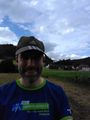
Obligatory stupid grin
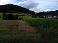
The hash point
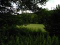
Looking the other direction


Other geohashing expeditions on the same day
Expeditions and Plans
| 2024-07-07 | ||
|---|---|---|
| Buffalo, New York | Pedalpusher, J | Shoulder of Main St, a little East of Clarence |
| Trieste, Italy | RidingBean | located in a vineyard in Dobrovo. |
| Szombathely, Hungary | coyotebush | Behind the Schmutterer market in Reisenberg. |
| Basel, Switzerland | Baarde | In a cornfield in Obersaasheim. |
| Stuttgart, Germany | LeslieHapablap | On a field near Bartenbach. |
| Bruxelles, Belgium | MyrtleGlacy | On a road in Waterschei |
| Goslar, Germany | Fippe | located on a field in Schladen. |
| Kempele, Finland | Kripakko | In a meadow near Svaaninsuo, Oulu. The point on a topographic map: [1] |
Achievements
LeslieHapablap earned the Land geohash achievement
|
LeslieHapablap earned the Walk geohash Achievement
|
LeslieHapablap earned the Speedrun achievement
|
Proof of the speedrun in the linked GPX: first track point at <time>2024-07-07T16:35:04.097Z</time> , last track point at <time>2024-07-07T17:19:57.258Z</time> .