Difference between revisions of "2024-07-06 45 -123"
Michael5000 (talk | contribs) (Created page with "{{subst:Expedition}}") |
m (Location) |
||
| (4 intermediate revisions by one other user not shown) | |||
| Line 9: | Line 9: | ||
-->{{meetup graticule|date=2024-07-06|lat=45|lon=-123}} | -->{{meetup graticule|date=2024-07-06|lat=45|lon=-123}} | ||
== Location == | == Location == | ||
| − | + | Way back in the Clatsop State Forest. | |
== Participants == | == Participants == | ||
| − | + | [[user:Michael5000|Michael5000]] | |
| − | + | ||
| + | == Expedition == | ||
| + | At midday on Saturday, I figured I'd drive over to the Coast to get a run in away from the interior's heat wave. I figured that many people would be heading for the Coast, which was correct, but that the traffic would have thinned by early afternoon, which was not correct at all. So, it took me quite some time to get to the wrong turnoff from US 26 into the forest. | ||
| − | + | I didn't have the map or connectivity, but I sensed fairly quickly that I was on a lower grade and curvier road than what I had envisioned. I pressed on, though, figuring that perhaps all of the forest roads eventually tie up together, and if I kept heading in the right direction, I would eventually get there. This, as it turned out, was not correct either. Once the relatively main branch I was driving on clearly was overshooting the hashpoint to the east, I went back and tried a side branch. This one actually proceeded in more or less the right direction until it entered a very large clearcut area, went around a bend, and abruptly ended. From here, I could look down across a valley to the north where, in the distance, I recognized the pattern of the road that I was actually supposed to be on. | |
| − | |||
| − | + | Twenty or thirty minutes got me back to the highway, and from there a minute or two got me to the road I should have been on in the first place. It was gated. | |
| − | |||
== Tracklog == | == Tracklog == | ||
| − | + | [[File:2024-07-06 45 -123.JPG]] | |
== Photos == | == Photos == | ||
| Line 36: | Line 36: | ||
__NOTOC__ | __NOTOC__ | ||
| − | |||
| − | |||
| − | |||
| − | |||
| − | |||
| − | |||
| − | |||
| − | |||
| − | |||
[[Category:Expeditions]] | [[Category:Expeditions]] | ||
| − | |||
| − | |||
| − | |||
| − | |||
| − | |||
| − | |||
| − | |||
| − | |||
| − | |||
[[Category:Coordinates not reached]] | [[Category:Coordinates not reached]] | ||
| − | |||
| − | |||
| − | |||
| − | |||
| − | |||
[[Category:Not reached - No public access]] | [[Category:Not reached - No public access]] | ||
| − | + | {{location|US|OR|CT}} | |
| − | |||
| − | |||
| − | |||
| − | |||
Latest revision as of 23:42, 7 July 2024
| Sat 6 Jul 2024 in 45,-123: 45.8323144, -123.3963326 geohashing.info google osm bing/os kml crox |
Location
Way back in the Clatsop State Forest.
Participants
Expedition
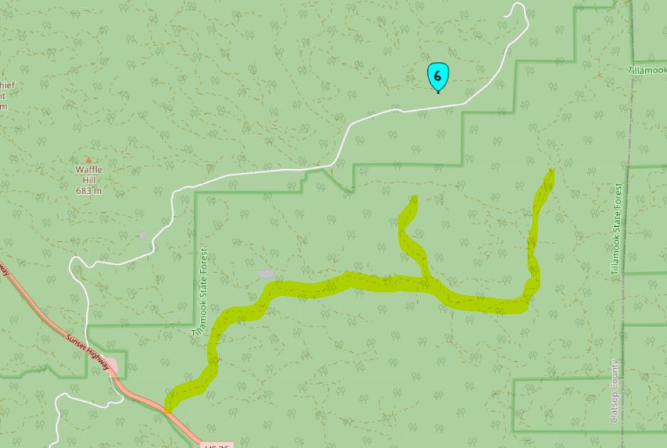
At midday on Saturday, I figured I'd drive over to the Coast to get a run in away from the interior's heat wave. I figured that many people would be heading for the Coast, which was correct, but that the traffic would have thinned by early afternoon, which was not correct at all. So, it took me quite some time to get to the wrong turnoff from US 26 into the forest.
I didn't have the map or connectivity, but I sensed fairly quickly that I was on a lower grade and curvier road than what I had envisioned. I pressed on, though, figuring that perhaps all of the forest roads eventually tie up together, and if I kept heading in the right direction, I would eventually get there. This, as it turned out, was not correct either. Once the relatively main branch I was driving on clearly was overshooting the hashpoint to the east, I went back and tried a side branch. This one actually proceeded in more or less the right direction until it entered a very large clearcut area, went around a bend, and abruptly ended. From here, I could look down across a valley to the north where, in the distance, I recognized the pattern of the road that I was actually supposed to be on.
Twenty or thirty minutes got me back to the highway, and from there a minute or two got me to the road I should have been on in the first place. It was gated.
