Difference between revisions of "2024-07-07 42 -78"
m (Location) |
m (Location) |
(No difference)
| |
Latest revision as of 01:42, 8 July 2024
| Sun 7 Jul 2024 in 42,-78: 42.9964317, -78.5292088 geohashing.info google osm bing/os kml crox |
Location
Shoulder of Main St, a little East of Clarence
Participants
Expedition
Had plans to maybe go to this when the hash-points were published, but was debating due to just being a half hour drive to turn around for a speed racer.
I mostly had the day to myself as J was visiting family and gone for most of the day. When her evening plans fell through, I decided to wait for her to come home and have some dinner before going as she was interested in joining me. I may have also forgotten about it after finishing up a couple errands around the house before playing some video games...but J reminded me when she called.
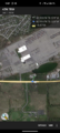
It was a very routine drive as we just got on Main St and drove for almost a half hour to the hash. Driving by, I got a picture of the hash area and then told J to turn around in one of the Business' driveways that were just past the hash. After getting back on the road, I told her to just drive a bit on the shoulder as we go past and I'll get a screenshot. I was shooting for a Speed Racer again, but there was some mis-communication, and she thought I was asking her to pull over at the hash. I was able to get a reading of 15 feet/ 5 meters as we drove by, but then I was confused why she was pulling over (she knows I usually like to get as close as possible to the hash). At least it made it easy to get some pics of the surrounding area before we pulled away, but that nullified the Speed Racer. I'll have to better explain the plan next time to avoid any confusion.
Back in Williamsville, we stopped at a local Brewery for a beer before completing the rest of the drive home.
Photos
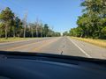
Initially driving past, a view of the hash area.
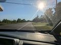
Now driving on the hash side of the road, we made it close enough going by. Not the speed limit, but fast enough the updates weren't too accurate.
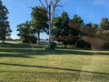
After pulling over just past the hash, a view to the North.
View West, back toward home.
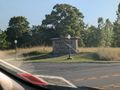
View East toward the Country Club entrance across the street from the hash.
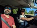
Standard Stupid Grins.


Ribbons
This user earned the Land geohash achievement
|