| Sun 11 Aug 2024 in 56,-4: 56.2477161, -4.1831870 geohashing.info google osm bing/os kml crox |
Contents
Location
In a wooded area near Callander.
Participants
Plans
KerrMcF
I'll drive here after volunteering, parking either at the nearby Bracklinn Falls car park or at the Station Road car park, likely at around 3pm. The route to the geohash is mostly along a path, which I will walk along.
Expedition
KerrMcF
In the time between planning this expedition and actually going on it, a couple of potential changes came up. The first of which involved a childhood friend (who now lives in England) coming up to Callander to visit family a couple of days before. There was a brief idea that we could attempt this geohash together, but they were leaving for Edinburgh in the morning. The second change also involved another potential drag-along, this time being my manager. The charity shop was having a bowling night out the day before the expedition, and he happened to ask where the points were. He's been keen to do it for a while now, and after hearing that it was in Callander and that I was going after volunteering, said that he might be able to make it as he was off work that day. It ended up being the case that he was unable to make it for the geohash because he was spending time with family, so the plans went back to the original ones of me going alone.
Today was a very nice sunny day, which might sound like a good thing - and it was, don’t get me wrong - but when everyone nearby also thinks it’s a nice sunny day, walking trails tend to get busy. When you’ve got a walking trail like this one, taking you directly to and over somewhere like Bracklinn Falls, it’s almost a guarantee that you’ll struggle to park nearby. I happened to get lucky today. As I was driving into their very small car park, another car happened to be driving out, leaving one singular space for me to pull into. Had I not had this luck, the expedition probably would’ve taken an hour or so more with the added walking distance.
That’s not to say that the journey there was fast by any means. After being stuck in a two separate conveys behind cars travelling far slower than they should’ve been, I was already slightly worried that I would be tight for time. I carried on though, starting the walk along the designated path. As strange as this might sound to be saying in Scotland, it was really quite nice to be hearing people speaking Gaelic as they walked past. It’s not something I come across often in the central belt, so it’s good to know that it’s definitely still common in some places.
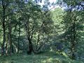
The walk along the gravel(?) path was very simple, and I reached the point where I had to turn off of the path with no issues. From that point on, it was along a grass path through a pretty dense forest. The entrance to this forest looked a little dark and spooky, but it was actually really great once I was inside it. There’s something about the deep unknown of the woods that really appeals to me. Maybe it’s the beams of sunlight poking through the trees, or the strong scent of pine from the ground. Or maybe it’s the darkness and the peace of it all. Whatever it is, I definitely enjoy walking through them. Unfortunately, the darker part didn't last for too long.
Eventually I reached the point where I had to go off-path towards the geohash, and realised it was maybe a little steeper and more overgrown than I'd expected. Regardless, I carefully made my way down the hill and reached the geohash. There was one lone fence post at the geohash, which may have been placed there to support a tree or something similar, but I couldn't find anything like that if this was the case. It was at the exact point of the geohash, I cannot stress that enough. Only once have I had something similar happen from what I can remember, and that was with a decorated tree. I took the photos that come alongside geohashing and decided to take the area in for a while.
I didn’t decide to go further down towards the river, because it got steeper relatively quickly, but the sound of the geohash was incredible. I’d assume I was hearing two or three different waterfalls, alongside the flow of the river itself. Could I hear the river flowing for the entire duration of my walk? Sure, but not nearly as prominent as that. This might’ve been somewhere I’d consider coming back to often if it wasn’t an hour’s drive away. As might be expected, the climb back up the hillside was significantly easier than the journey down. The accompanying sound of a rescue helicopter above, however, was not the most comforting.
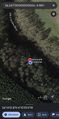
The walk back was also easier, mostly because I already knew the route, and I reached the car 20 minutes after leaving the geohash. The drive back home was also relatively simple, and took about an hour. I've made a habit of mentioning this in reports recently, so I'll continue it. I didn't pass the Bardowie geohash on the way to this one, but both the drive there and the drive back passed by 2024-02-21 56 -4, making the drive feel relatively familiar. As a whole, the expedition took me about 2hrs 40mins, from 2:55pm to 5:35pm.
Photos
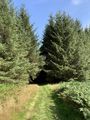
The entrance to the forest
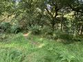
Leaving the path
At the geohash
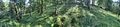
Wider view
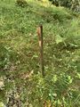
The geohash fence post
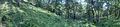
Panorama from the geohash
Another to convey the angle

Me at the geohash
The river is down there
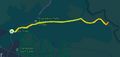
Walking route


Achievements
KerrMcF earned the Land geohash achievement
|
Progress
| Council Area | Postcode | NUTS | Centicule | New Achievements |
|---|---|---|---|---|
| Stirling | FK(17) | UKM77 | 21 | N/A |
| Expedition Navigation | ||
|---|---|---|
| KerrMcF's expeditions | No Next Yet | |