2024-02-21 56 -4
| Wed 21 Feb 2024 in 56,-4: 56.2168098, -4.2409063 geohashing.info google osm bing/os kml crox |
Contents
[hide]Location
In a forest on Ben Gullipen.
Participants
Plans
KerrMcF
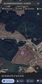
After volunteering, I plan to drive to what looks like a small rest section on the side of the A81 and then walk to the point via a small track. I aim to reach the point at around 4pm but traffic delays may change this. I should reach home at around 5pm, resulting in a total time of 2 hours for the expedition.
Expedition
KerrMcF
I left volunteering later than planned, around 3:20pm, but the journey towards the rest section was simple enough. It began raining about halfway through the drive but this stopped before I had to get out of the car. The majority of the route was quite similar to my drive for 2024-01-28 56 -4, with the main difference of today's expedition being fully along main roads rather than single-track rural roads. After parking up at the rest section, I crossed the road and began my journey uphill.
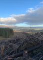
I hadn't realised the extent of the climb from the streetview, but it wasn't overly difficult. The initial climb took me longer than I expected due to its steepness, but after about 15 minutes I reached the top. The view behind me was beautiful, and it reminded me of my appreciation that I don't live in a flat country or an overly urban setting. I passed three or so sheep on the way up, at least one of which had a very impressive set of horns. I didn't take a photo as my focus was on walking, but the silent observation from wild animals always amuses me during these trips. The confusion and curiosity as to my unexpected presence is a universal experience among them, and as much as I worry they may suddenly become aggressively defensive, I'm getting more used to it over time.
Reaching the top of this section, I realised that this may be a relatively common walking route so far. There was a signpost with directions to nearby towns in a format often seen on walking paths, and I wondered if I'd encounter any others during my trip. Neither direction was one I was heading in though, as I now needed to go off-road to reach the point. From the aerial imagery, I had assumed this would be a relatively flat path with minimal incline, but this next section was far steeper than the previous climb. At least it would be shorter! I should have probably taken a photo of this to demonstrate it, but a small portion of it can be seen behind the signpost in the image below.
After a relatively tricky summit of the hill, avoiding pools of water and sharp branches, I reached the geohash. It was almost at the top of this portion of the hill, and if the weather had been on the worse side, I probably wouldn't have even attempted to go beyond the gravel track due to the nature of the ground. I took screenshots of proof, found that the geohash was directly on a tree stump, and took my panorama from the point. The view was incredible in person, and I'm slightly disappointed with the lack of how this came across in the photo. I was surrounded by fallen trees as the photo shows, but beyond that was an amazing view of the landscape which I suppose the beauty of which could not be fully captured with my level of photography. I took my Bereal, something I plan to do on every expedition that I carry out, and began to consider my descent.
I'd realised halfway up the climb that I'd forgotten to start tracking my route, so I started doing so from the geohash on my way back to the car. It's not as accurate of a representation of my climb, but it'll do. As is typically the case with hills, the best route is easier to see on your way back down. As such, I was far quicker descending the off-road portion than summiting it, but that thought left my mind quite quickly. It had started to rain, very lightly, and the clearest rainbow I had ever seen was shining right in front of me. I couldn't not take a photo or two, so I've posted them below. Again, either the nature of photography or my extent of photographic skills could not capture how incredible the sight truly was, but when I say that the rainbow was perfect in shape, size, colour, and consistency, I am being fully genuine.
The descent of the hill was simple enough, far faster than the climb, but I slowed down anyway to enjoy the nature around me. Then I heard a voice. I couldn't see anyone at first, so kept walking, but after a couple more debates on whether that was actually a voice or I was hallucinating, I noticed a man in a red jacket standing in the near distance. As I got closer and could focus my attention on something physically there, I realised he was shouting the name Alfie, likely aimed at a dog (which I could not see). He was on the other side of a wide valley of trees which would eventually meet my path at the signpost. I don't think he was geohashing, but there's a definite chance of it. If he was and happens to read this, I hope you managed to reach the point. If he wasn't, then I hope he managed to get his dog to come back to him.
I reached the bottom of the track, crossed the road again, and got into the car. The drive back was absolutely fine, with only minor issues from the sunset shining at eye level, and I reached home at around 5:20pm. Considering I left 20 minutes later than expected and got back home 20 minutes later than expected, I must say that the expedition went perfectly. Unfortunately, my two day streak of geohashing comes to an end with this, as I have no time tomorrow to continue it, despite the next point being relatively accessible.
Photos
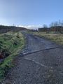
The beginning climb to the geohash
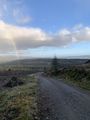
View from the top of this beginning climb
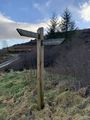
Directional signpost, none of the two were for my journey
Reached the geohash
Further view of the geohash
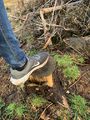
Standing on the exact point
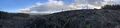
Panoramic view from the geohash

Bereal photo taken from the geohash
Other side of the Bereal
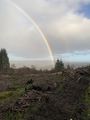
Photo of the rainbow from walking back down
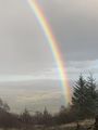
Closer photo of the rainbow
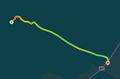
Route from the geohash to the car


Achievements
KerrMcF earned the Land geohash achievement
|
KerrMcF earned the Last man standing achievement
|
KerrMcF earned the Consecutive geohash achievement
|
Progress
| Council Area | Postcode | NUTS | Centicule |
|---|---|---|---|
| Stirling | FK(17) | UKM77 | 22 |
| Expedition Navigation | ||
|---|---|---|
| KerrMcF's expeditions | Next | |