2024-03-10 55 -4
| Sun 10 Mar 2024 in 55,-4: 55.7746552, -4.8130583 geohashing.info google osm bing/os kml crox |
Contents
[hide]Location
In the Clyde Muirshiel Regional Park close to the Kelburn Wind Farm.
Participants
- KerrMcF
- KerrMcF's dad
Plans
KerrMcF
After my volunteering, my dad and I plan to drive to the parking area at the entrance to the Kelburn Wind Farm. We'll try to reach the point at around 3:30pm but this depends on traffic. We should get home at around 4:30pm, giving the expedition a rough total time of 2 hours.
This point is my second attempt in the Clyde Muirshiel Regional Park, hopefully this time the ground will be more suitable for walking across.
Expedition
KerrMcF
I left volunteering at 2pm as I had planned and got home at around 2:10pm. We'd recently gotten a new car - a Ford Puma ST - which my dad had been very keen to drive a longer distance, so we'd agreed that he would drive down to the point. We started the drive almost immediately after I got home, reaching the parking area at around 3:10pm.
The weather had been fine when we left, and fine for most of the drive, but typically as we reached the final few miles of our trip the rain began to pour and the wind began to howl. The journey to the point wasn't going to take long - about 15 minutes there and 10 minutes back - and we'd prepared enough to pack jackets and walking boots, but I was dreading another unsuccessful expedition in this region.
We changed our shoes and braced against the weather, beginning our walk towards the point. Most of our route there was paved as it was a private road leading to the Kelburn Wind Farm a couple of miles away. We passed several sheep (one of which was very close to the side of the road and was not at all scared of us) and saw a heron struggling to fly against the wind several times before giving up.
The point at which I'd previously planned for us to leave the paved road conveniently had a gate at that exact point in the fence, allowing us to easily climb over into the field. Travelling across this and into the adjacent field via a fallen fence allowed us to reach the point quite easily. We did have to half-jump across several small streams, but this was no issue. We took our photos and briefly admired the view before heading back towards the car. If it had been a sunnier day, we might have stayed for longer. The point was reached at 3:25pm, almost exactly as planned.
The way back was harsher, the wind was blowing directly into our faces for the majority of this section and we were becoming colder and colder. It's not the worst weather I've geohashed in - 2024-01-28 56 -4 by far takes that place - but it definitely wasn't the most ideal. We passed by the sheep again, still unbothered by our closeness, so I took a photo to post here. The heron was still struggling against the wind, but it had started making progress!
Reaching the car was nice, we changed our shoes back and left our jackets in the boot before getting into the warmth and comfort and beginning our drive back. It was quite a nice drive, and it was good to know that the expedition had been successful. Daniel was sad to be missing out, but I'm sure his afternoon was at least warmer than ours. We got home at about 4:30pm, giving the expedition a total time of 2 hours and 15 minutes. Not too bad for my dad's first expedition!
Photos
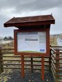
Sign at the entrance to the wind farm
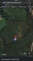
Reached the geohash
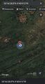
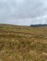
Zoomed out view of geohash
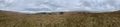
Panoramic view from the geohash
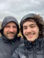
Bereal photo taken from the geohash
Other side of the Bereal
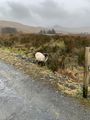
Sheep that we passed both ways
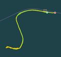
Walking route of the expedition


Achievements
KerrMcF and KerrMcF's dad earned the Land geohash achievement
|
KerrMcF earned the Drag-along achievement
|
Progress
| Council Area | Postcode | NUTS | Centicule |
|---|---|---|---|
| North Ayrshire | KA(29) | UKM93 | 78 |
| Expedition Navigation | ||
|---|---|---|
| KerrMcF's expeditions | Next | |
| No Previous | KerrMcF's Dad's expeditions | Next |