2024-09-06 42 -78
| Fri 6 Sep 2024 in 42,-78: 42.3727633, -78.3543048 geohashing.info google osm bing/os kml crox |
Location
Bush Hill State Forest
Participants
Expedition
The weather wasn't great and it was pretty far away, but I considered it for two reasons: it would add to my Centicule Map completion and the route to the hash would take us directly past J's Mom's new house. J was hesitant with the weather, but without much of a plan for the evening, she agreed to go.
We did have to scramble a bit to get ready immediately after work because we needed to be on the way ASAP. It looked like it wasn't too far off the Finger Lakes Trail (FLT), but it would be an estimated 2+ miles (3.6+ KMs) from the trailhead. I figured I could then just keep heading North from the hash to hit the Forest Road to walk back to the car as I didn't want to get caught in the woods after dark and it would be easier on the road.
When we got down by J's Mom's place, J decided to stop there with the clouds threatening and I then continued on my way. As I got closer, I started to worry that I wouldn't even want to get out of the car if it was raining hard like the clouds ahead of me looked like they were doing. I was paying attention to the odometer and with a couple turns left before the Forest, I got to see it hit all 8s and I pulled over for a moment to grab a picture. I know 8s are lucky in Asian culture, and it seemed to be a good omen. I did drive through some rain, but right as I got there, the rain let up and it was just lightly sprinkling. Then, even more luck was had when I found the gate at the head of the Forest Road was open! I could then basically drive almost to the hash and just have a short walk through the woods.
The road was very well maintained (or recently improved) as there were barely any potholes, and I was able to close in on the hash to under a half mile (1 KM) where I found a pull-off to park and get off the one lane forest road. There seemed to be an old trail or maybe an old logging road that I was able to follow a ways before I had to break off into the woods. I grabbed my headlamp when I was getting ready and I'm glad I did because at this point, the clouds were making it pretty dark in the woods. Rather than fumble around with in later, I put it on and turned it on. It did help a bit, but as I got to the hash, it lightened up again so I didn't need it on any longer.
Once at the hash, I had to make a longer than normal GPS dance, but I was still able to use the HashDroid app and eventually got a good reading. With plenty of daylight left (and the sun even came out), I started on my way back and came across another branch of the FLT that wasn't marked on Open Street Maps. It looked like it was going the right way, and a trail is always easier than bushwhacking so I followed it, and ended up on the road! I hit a fork on the main forest road and initially started going the wrong way, but quickly realized my mistake and turned around and found the car around a couple turns in the road.
In our scramble to get ready, we didn't have time to grab anything (or stop anywhere) for dinner, so after swinging by to pick up J, we then hit a nice restaurant that wasn't too far out of the way home.
Photos

Got to see the Odometer change to all 8s!
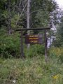
Taken on the way out, but the Forest Signage next to the Forest Road.
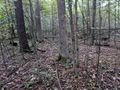
Made it!

Slightly damp, but nowhere near a Drowned Rat!

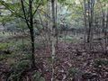
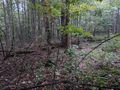
View North from the hash, looking toward where I came in from.
Sorry for the blurry view to the West.
The view South.
And finally the view East.
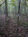
On the way out, I found the FLT spur trail and followed it out.
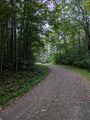
Back on the forest road, the car around the last bend.


Ribbons
This user earned the Land geohash achievement
|