Difference between revisions of "Atlantic City, New Jersey"
imported>Jevanyn m (Spelling fail) |
imported>Jevanyn (→Daily Locations) |
||
| Line 33: | Line 33: | ||
Older locations have been [[Atlantic City, New Jersey/archive|archived]]. | Older locations have been [[Atlantic City, New Jersey/archive|archived]]. | ||
| − | *8/ | + | * 8/10/08 |
| − | + | On the bank of a fairly small lake, across Raritan Ave from Atsion Lake, in Wharton State Forest. The closest town is Parkdale to the south. | |
| − | *8/6/08 | + | * 8/8/08 |
| + | [[Image:Atlantic_City_Expressway_svg.png|32px]] Undeveloped woodland near Broad Lane, near West Fleming Pike / Winslow Road. AC Expwy exit 33 (southbound only). | ||
| + | |||
| + | * 8/7/08 | ||
| + | [[Image:Atlantic_City_Expressway_svg.png|32px]] A farmer's field along the Atlantic City Expressway, near NJ 54 (AC Expwy Exit 28). | ||
| + | |||
| + | * 8/6/08 | ||
The [[Philadelphia, Pennsylvania|Philladelphia (South)]] geohash is on Fries Mill Road, north of the town of Fries Mill and southeast of Glassboro. Maybe he's related to the guy on Futurama? | The [[Philadelphia, Pennsylvania|Philladelphia (South)]] geohash is on Fries Mill Road, north of the town of Fries Mill and southeast of Glassboro. Maybe he's related to the guy on Futurama? | ||
| − | *8/5/08 | + | * 8/5/08 |
| − | Horicon Road, | + | Horicon Road, Cedar Glen Lakes. Just east of Fort Dix. |
| − | *8/4/08 | + | * 8/4/08 |
The [[Philadelphia, Pennsylvania|Philadelphia (South)]] geohash is just off NW Blvd in Vineland. | The [[Philadelphia, Pennsylvania|Philadelphia (South)]] geohash is just off NW Blvd in Vineland. | ||
| − | |||
| − | |||
| − | |||
| − | |||
| − | |||
| − | |||
| − | |||
| − | |||
| − | |||
| − | |||
| − | |||
| − | |||
| − | |||
| − | |||
| − | |||
| − | |||
| − | |||
| − | |||
| − | |||
| − | |||
| − | |||
[[Category:New Jersey]] | [[Category:New Jersey]] | ||
[[Category:Active Graticules]] | [[Category:Active Graticules]] | ||
Revision as of 14:00, 8 August 2008
| Philadelphia, PA (North) | Newark | New York, NY |
| Philadelphia, PA (South) | Atlantic City, New Jersey | – |
| Salisbury, MD | Cape May | – |
[[Category:Meetup in {{{lat}}} {{{lon}}}| ]]
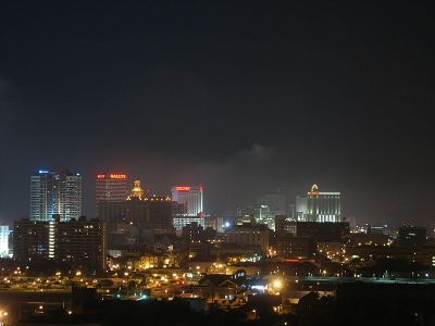
The Atlantic City graticule is at 39 N, -74 W. It encloses nearly all of South Jersey, including the majority of the Jersey Shore, from Dover Beaches and Seaside Heights to North Wildwood. Roughly a third of this graticule is in the Atlantic Ocean. A small chunk of Delaware Bay is also enclosed.
Places in this Graticule
Cities
- Atlantic City, NJ
- Toms River, NJ
- Ocean City, NJ
- Marlton, NJ (A suburb of Camden)
- near Philadelphia, PA
- Fort Dix, NJ (split)
State parks & wildlife areas
Local Geohashers
Daily Locations
Older locations have been archived.
- 8/10/08
On the bank of a fairly small lake, across Raritan Ave from Atsion Lake, in Wharton State Forest. The closest town is Parkdale to the south.
- 8/8/08
![]() Undeveloped woodland near Broad Lane, near West Fleming Pike / Winslow Road. AC Expwy exit 33 (southbound only).
Undeveloped woodland near Broad Lane, near West Fleming Pike / Winslow Road. AC Expwy exit 33 (southbound only).
- 8/7/08
![]() A farmer's field along the Atlantic City Expressway, near NJ 54 (AC Expwy Exit 28).
A farmer's field along the Atlantic City Expressway, near NJ 54 (AC Expwy Exit 28).
- 8/6/08
The Philladelphia (South) geohash is on Fries Mill Road, north of the town of Fries Mill and southeast of Glassboro. Maybe he's related to the guy on Futurama?
- 8/5/08
Horicon Road, Cedar Glen Lakes. Just east of Fort Dix.
- 8/4/08
The Philadelphia (South) geohash is just off NW Blvd in Vineland.
