Difference between revisions of "2008-12-18 48 12"
imported>Dawidi (New page: {{subst:Expedition |image = filename |lat = 49 |lon = 12 |date = 2008-12-17 }}) |
imported>FippeBot m (Location) |
||
| (2 intermediate revisions by one other user not shown) | |||
| Line 1: | Line 1: | ||
| − | + | [[Image:2008-12-18 48 12 from the hash with slow flash.jpg|thumb|left]] | |
| − | |||
| − | [[Image: | ||
{{meetup graticule | {{meetup graticule | ||
| − | | map=<map lat= | + | | map=<map lat=48 lon=12 date=2008-12-18 /> |
| − | | lat= | + | | lat=48 |
| lon=12 | | lon=12 | ||
| − | | date=2008-12- | + | | date=2008-12-18 |
}} | }} | ||
| − | |||
__NOTOC__ | __NOTOC__ | ||
| − | |||
| + | In a field, 500m south of Neutraubling, 10km southeast of Regensburg. | ||
| + | |||
| + | == [[User:Dawidi|dawidi]] == | ||
| − | + | Since contrary to the weather forecast, it hadn't been snowing or raining all day, I rather spontaneously decided to do this expedition after work - a 20km detour from my usual 7km way back home. The entire trip would take place long after sunset, but the batteries in my GPS and LED headlight were good and the darkness wouldn't really be a problem. | |
| + | The first 9.5 km of the trip were rather unremarkable, just a familiar ride through an industrial area on wide, dedicated cycleways. Then I took a somewhat muddy track leading out into the fields. The last part I could ride were a level railroad crossing and then a few meters of field track with very sticky mud which threatened to block my wheels, so I quickly parked the bike and prepared to do the last 140 meters on foot. | ||
| − | + | Entering the field, I immediately knew what I had already suspected - these less than 500 feet would be the heaviest (and the hardest) of the whole trip. My shoes picked up about 1kg of mud on every step, then after reaching maybe 5kg, half the weight dropped off, only to be replaced by more mud on subsequent steps. | |
| + | Also, I had to navigate by GPS exclusively! The field itself was very uniform, the surroundings so dark and the lights on the horizon seemed so far away (even though it was only 500m) that I could not see myself moving at all; so I simply kept trudging on until the GPS indicated I'd reached the spot. A really weird experience. | ||
| − | + | From the hashpoint I could just barely see some reflection from my bike and the St. Andrew's cross sign at the crossing when I shone my headlight there, apart from that it was all mud in any direction. I took a few pictures of myself and the surroundings, then trudged back, guided by the GPS. Back at the bike, I took some more pictures using the saddle as an elevated tripod. | |
| + | |||
| + | Before I could begin the ride back home, I took about a quarter of an hour to find a suitable stick and use it to remove at least some of the dirt that had stuck to my shoes, and between the wheels and mudguards on my bike. The trip home was then rather uneventful again. | ||
| + | |||
| + | As of the morning after, I have yet to clean my shoes and the bike... | ||
== Photos == | == Photos == | ||
| − | <gallery | + | <gallery> |
| − | Image:2008- | + | Image:2008-12-18 48 12 dawidi at the hash.jpg | at the hash (long exposure) |
| − | Image:2008- | + | Image:2008-12-18 48 12 gps.jpg | within accuracy range |
| + | Image:2008-12-18 48 12 from the hash with slow flash.jpg | view from the hash (with long exposure and flash) | ||
| + | Image:2008-12-18 48 12 dirty shoe.jpg | the field was very attractive | ||
| + | Image:2008-12-18 48 12 dawidi from the bike.jpg | back at my bike | ||
| + | Image:2008-12-18 48 12 from the bike.jpg | view from the bike to the hash | ||
| + | Image:2008-12-18 48 12 dirty bike.jpg | ewwww... | ||
| + | Image:2008-12-18 48 12 railroad bridge.jpg | bridge over the nearby stream | ||
| + | Image:2008-12-18 48 12 railroad crossing.jpg | view from the railroad to the hash | ||
</gallery> | </gallery> | ||
| − | |||
| − | |||
| − | |||
| − | |||
[[Category:Expeditions]] | [[Category:Expeditions]] | ||
[[Category:Expeditions with photos]] | [[Category:Expeditions with photos]] | ||
| − | |||
| − | |||
| − | |||
[[Category:Coordinates reached]] | [[Category:Coordinates reached]] | ||
| − | + | {{location|DE|BY|R}} | |
| − | |||
| − | |||
| − | |||
| − | |||
| − | |||
| − | |||
Latest revision as of 01:05, 8 August 2019
| Thu 18 Dec 2008 in 48,12: 48.9695583, 12.1894155 geohashing.info google osm bing/os kml crox |
In a field, 500m south of Neutraubling, 10km southeast of Regensburg.
dawidi
Since contrary to the weather forecast, it hadn't been snowing or raining all day, I rather spontaneously decided to do this expedition after work - a 20km detour from my usual 7km way back home. The entire trip would take place long after sunset, but the batteries in my GPS and LED headlight were good and the darkness wouldn't really be a problem.
The first 9.5 km of the trip were rather unremarkable, just a familiar ride through an industrial area on wide, dedicated cycleways. Then I took a somewhat muddy track leading out into the fields. The last part I could ride were a level railroad crossing and then a few meters of field track with very sticky mud which threatened to block my wheels, so I quickly parked the bike and prepared to do the last 140 meters on foot.
Entering the field, I immediately knew what I had already suspected - these less than 500 feet would be the heaviest (and the hardest) of the whole trip. My shoes picked up about 1kg of mud on every step, then after reaching maybe 5kg, half the weight dropped off, only to be replaced by more mud on subsequent steps.
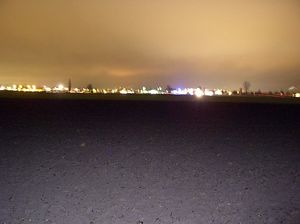
Also, I had to navigate by GPS exclusively! The field itself was very uniform, the surroundings so dark and the lights on the horizon seemed so far away (even though it was only 500m) that I could not see myself moving at all; so I simply kept trudging on until the GPS indicated I'd reached the spot. A really weird experience.
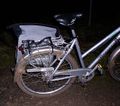
From the hashpoint I could just barely see some reflection from my bike and the St. Andrew's cross sign at the crossing when I shone my headlight there, apart from that it was all mud in any direction. I took a few pictures of myself and the surroundings, then trudged back, guided by the GPS. Back at the bike, I took some more pictures using the saddle as an elevated tripod.
Before I could begin the ride back home, I took about a quarter of an hour to find a suitable stick and use it to remove at least some of the dirt that had stuck to my shoes, and between the wheels and mudguards on my bike. The trip home was then rather uneventful again.
As of the morning after, I have yet to clean my shoes and the bike...


