Difference between revisions of "2009-01-09 33 -84"
imported>Woodveil m (New page: {{meetup graticule | map=<map lat="33" lon="-84" date="2009-01-09" /> | lat=33 | lon=-84 | date=2009-01-09 | graticule_name=Atlanta | graticule_link=Atlanta, Georgia }} ==Expeditions== F...) |
imported>FippeBot m (Location) |
||
| (5 intermediate revisions by one other user not shown) | |||
| Line 17: | Line 17: | ||
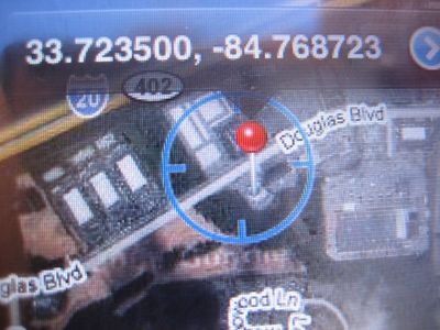
<gallery caption="The Map" widths="450px" heights="300px" > | <gallery caption="The Map" widths="450px" heights="300px" > | ||
| − | + | Image:2009-01-09 coordinates.jpg| There we are. | |
</gallery> | </gallery> | ||
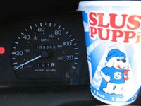
<gallery caption="The Evidence" widths="200px" heights="200px" perrow="3"> | <gallery caption="The Evidence" widths="200px" heights="200px" perrow="3"> | ||
| − | + | Image:2009-01-09 odometer 1.jpg|We picked up geoSquishees from a Chevron station. Note the odometer reading (121.0) | |
| + | Image:2009-01-09 Chris S.jpg|Taken in the meantime. | ||
| + | Image:2009-01-09 odometer 2.jpg|It was just over half a mile from the geoSquishee vendor to the hashpoint. | ||
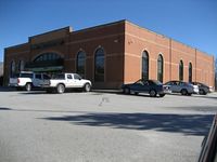
| + | Image:2009-01-09 sign.jpg| There's the sign | ||
| + | Image:2009-01-09 Store.jpg| And there's the store. The hashpoint was on the wall to the right, by the fourth window. | ||
| + | Image:2009-01-09 both.jpg| ''This'' window. | ||
</gallery> | </gallery> | ||
| Line 35: | Line 40: | ||
</tr> | </tr> | ||
</table> | </table> | ||
| − | {{GeoSquishy FirstSip | latitude = 33 | longitude = -84 | date = 2009-01-09 | + | {{GeoSquishy FirstSip | latitude = 33 | longitude = -84 | date = 2009-01-09 | image = 2009-01-09 both.jpg }} |
[[Category:Expeditions]] | [[Category:Expeditions]] | ||
| Line 41: | Line 46: | ||
[[Category:Coordinates reached]] | [[Category:Coordinates reached]] | ||
[[Category:Expedition without GPS]] | [[Category:Expedition without GPS]] | ||
| + | {{location|US|GA|DL}} | ||
Latest revision as of 01:18, 8 August 2019
| Fri 9 Jan 2009 in Atlanta: 33.7235006, -84.7687233 geohashing.info google osm bing/os kml crox |
Expeditions
Fresh off of the previous day's expedition, We were anxious to know the new hashpoint. A quick check found it to be West of town, very near I20, and inside of a large building. A further inspection using Google's Street View revealed that building to be none other than a liquor store (which immediately opened up a Pandora's Box of geohashing possibilities. I'm sure you can think of a few). But being a bit underage, we found it quite fortunate that the actual hashpoint was located close* to the perimeter of the building, near some parking spots. *close in this context meaning inside of ten feet.
Quickly perusing the Wiki for possible achievements before we left, we settled on a GeoSquishy attempt. The drive to the point was fairly uneventful, and we stopped at a gas station just before the hashpoint to acquire the necessary weaponry. A short half-mile drive from there brought us to the actual hashpoint, where we proceeded to count parking spaces until we determined definitively which spot on the side of the liquor store was nearest to the hash. Then we leaned against it, drinking our Squishees and basking in the warm, glowing, warming glow of another successful geohash.
Gallery
- The Map
- The Evidence
Achievements
This user earned the Land geohash achievement
|
This user earned the No Batteries Geohash Achievement
|
This user earned the Consecutive geohash achievement
|
| This user earned the 5-Star geoSquishy achievement |
This user earned the First Sip GeoSquishy Achievement
|


