Difference between revisions of "2009-01-12 48 12"
imported>Tomcat |
imported>Thomcat m |
||
| Line 4: | Line 4: | ||
{{meetup graticule | {{meetup graticule | ||
| map=<map lat="48" lon="12" date="2009-01-12"/> | | map=<map lat="48" lon="12" date="2009-01-12"/> | ||
| − | | lat= | + | | lat=48 |
| lon=12 | | lon=12 | ||
| date=2009-01-12 | | date=2009-01-12 | ||
Revision as of 20:54, 12 January 2009
[[Image:|thumb|left]]

| Mon 12 Jan 2009 in Landshut, Germany: 48.9716227, 12.1939858 geohashing.info google osm bing/os kml crox |
In a field, 500m south of Neutraubling, 10km southeast of Regensburg.
Morning visit (dawidi)
Evening visit (Tomcat)
Originally i had not intended to visit todays 48 12 hashpoint. But as things happen - finally i had to left office already in the afternoon to settle things in the city. On a closer look at Google Earth, i realized that the hashpoint was only about 500m away from the shop for animal need, where i usually buy stuff for my cat. So it was a clear decision, that this shop had to be visited today ;-)
Due to the actual weather conditions it was a fast, simple and clean expedition. I parked my car beside the road an walked along the way between the snowcovered and frozen fields to a point where suddenly some tread marks lead into the field to my right. I just had to follow this trace until i reached the signs "xkcd". Then i took the usual photos and walked back to the road.

The way to the hashpoint.
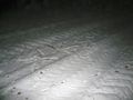
Signs of my predecessor at the hashpoint.
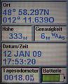
Exactly at the right spot.
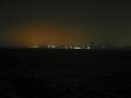
The lights of Neutraubling seen from the hashpoint.


