Difference between revisions of "2009-04-03 35 -78"
From Geohashing
imported>Ncbears (Holy Hash) |
imported>Ncbears m (edit) |
||
| Line 35: | Line 35: | ||
<gallery widths="100px" align=center> | <gallery widths="100px" align=center> | ||
Image:Landgeohash.png|[[Land Geohash]] | Image:Landgeohash.png|[[Land Geohash]] | ||
| − | Image:Holyhash.png|[[ | + | Image:Holyhash.png|[[Holy_hash_achievement|Holy Hash]] |
| − | + | </gallery> | |
[[Category:Expeditions]] | [[Category:Expeditions]] | ||
[[Category:Expeditions with photos]] | [[Category:Expeditions with photos]] | ||
[[Category:Coordinates reached]] | [[Category:Coordinates reached]] | ||
Revision as of 17:57, 22 May 2009
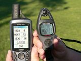
| Fri 3 Apr 2009 in 35,-78: 35.8419982, -78.3250850 geohashing.info google osm bing/os kml crox |
Report
Hash was located in a side yard next to church parking lot. Friendly parishioners waved to us while we were taking pictures.
Participants
Geological Features
Slightly rolling residential area. Church grounds.
Wildlife Encounters
None
Weather
Low 72.1°F/22.3°C, sunny, light breeze
Pictures
On location
- Error creating thumbnail: Unable to save thumbnail to destination
Side yard next to parking lot

There’s the church
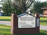
Holy Hash Baptist Church


