Difference between revisions of "2009-04-20 67 20"
From Geohashing
imported>The ru m |
imported>The ru |
||
| Line 25: | Line 25: | ||
| longitude = 20 | | longitude = 20 | ||
| date = 2008-04-20 | | date = 2008-04-20 | ||
| − | | name = [[User:the_ru|the ru]] | + | | name = [[User:the_ru|the ru]] and [[User:Jeppzer|Jeppzer]] |
| + | | image = 2009-04-20_67_20_proof.jpg | ||
}} | }} | ||
| − | + | <gallery perrow="3"> | |
| − | + | Image:2009-04-20_67_20_kiruna.jpg | Kiruna by night | |
| − | | | + | Image:2009-04-20_67_20_proof.jpg | |
| − | + | Image:2009-04-20_67_20_tree.jpg | Jeppzer and the geohash tree | |
| − | + | </gallery> | |
| − | |||
| − | |||
[[Category:Expeditions]] | [[Category:Expeditions]] | ||
[[Category:Coordinates reached]] | [[Category:Coordinates reached]] | ||
Revision as of 09:04, 20 April 2009
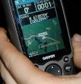
| Mon 20 Apr 2009 in 67,20: 67.8570420, 20.2894693 geohashing.info google osm bing/os kml crox |
The hashpoint was just outside Kiruna, near the golf course.
Geohashers in attendance
We were there at midnight. There were snowmobile tracks leading almost all the way to the hash, they were hard enough to walk on (600 m, one way) so we didn't need skis for this one.
When we had just reached the hashpoint, we started hearing agonizing shrieks of terror coming from the forest. Was it a banshee? An owl? An uolta? We will never know.
the ru had brought balls and juggled a bit, but the poor lighting (interrupted by blinding camera flashes) made it difficult.
| “ | I forgot my memory
|
” |
—the ru
| ||
the ru and Jeppzer earned the Midnight Geohash achievement
|
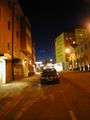
Kiruna by night
- 2009-04-20 67 20 tree.jpg
Jeppzer and the geohash tree

