Difference between revisions of "2009-05-01 49 7"
imported>Fivetonsofflax m (→Plans) |
imported>FippeBot m (Location) |
||
| (2 intermediate revisions by one other user not shown) | |||
| Line 10: | Line 10: | ||
__NOTOC__ | __NOTOC__ | ||
== Participants == | == Participants == | ||
| − | [[User:Euterkuh|Euterkuh]] and [[User:fivetonsofflax|fivetonsofflax]]. In case you're wondering why we always go on expeditions together: fivetonsofflax owns a GPS device but neither a cell phone nor a camera, so we kind of depend on each other. | + | [[User:Euterkuh|Euterkuh]] and [[User:fivetonsofflax|fivetonsofflax]]. In case you're wondering why we always go on expeditions together: fivetonsofflax owns a GPS device but neither a Bluetooth capable cell phone nor a camera, so we kind of depend on each other. |
== Plans == | == Plans == | ||
| Line 67: | Line 67: | ||
| image = 2009-05-01 49 7 16.JPG | | image = 2009-05-01 49 7 16.JPG | ||
| + | }} | ||
| + | {{Minesweeper geohash | ||
| + | | graticule = Mannheim, Germany | ||
| + | | ranknumber = 1 | ||
| + | | w = true | ||
| + | | name = [[User:fivetonsofflax|fivetonsofflax]] | ||
| + | }} | ||
| + | {{Minesweeper geohash | ||
| + | | graticule = Mannheim, Germany | ||
| + | | ranknumber = 1 | ||
| + | | w = true | ||
| + | | name = [[User:Euterkuh|Euterkuh]] | ||
}} | }} | ||
| Line 72: | Line 84: | ||
[[Category:Expeditions with photos]] | [[Category:Expeditions with photos]] | ||
[[Category:Coordinates reached]] | [[Category:Coordinates reached]] | ||
| + | {{location|DE|RP|DÜW}} | ||
Latest revision as of 03:08, 8 August 2019
| Fri 1 May 2009 in 49,7: 49.3983246, 7.9694507 geohashing.info google osm bing/os kml crox |
Participants
Euterkuh and fivetonsofflax. In case you're wondering why we always go on expeditions together: fivetonsofflax owns a GPS device but neither a Bluetooth capable cell phone nor a camera, so we kind of depend on each other.
Plans
Both this point and the hashpoint in our home graticule 49 8 could be reached with our students' tickets. We decided for this one in order to get to the first level of the Minesweeper achievement. Since the hashpoint was very close to the station of Weidenthal, there wasn't a lot of preparation to be done.
Expedition
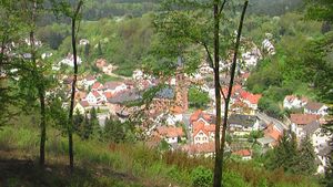
As Euterkuh is too lazy to upload map data to his cell phone, all we had to help us get to the hashpoint was the linear direction from the GPS device. Enjoying the pleasant weather, we left Weidenthal to the south and had soon worked off a few hundred meters of the overall distance of 2.8 km as the crow flies. Around the village, the landscape was quite pleasant, but the further we got into the forest, the more monotonous it got. We could follow the paths first, but after a while, we didn't really get any closer to the point this way and decided to walk straight through the woods. It's a very hilly area and being the couch potatoes that we are, it was quite exhausting.
We actually encountered a lot of paths ("I think I see a path over there" was one of the most frequent sentences of the expedition), but unfortunately, most of them pretty much crossed the direction we were heading at right angle. Euterkuh was getting delirious ("Shh! Be quiet! I think I heard a granny.") and fivetonsofflax earned himself a Raptor achievement but eventually we arrived, two hours after having started from Weidenthal. We took photos but forgot to leave a mark; to be honest, the forest was starting to annoy us and we wanted to get back to the village quickly. Forunately, there was a country lane in a short distance to the West. This was more boring than the way through the forest, but it only took us an hour.
Back in Weidenthal, we stumbled upon a small party of the local auxiliary fire brigade. We sat down for a while, had some wheat beer and made fun of the local dialect. After that, it was back to Heidelberg.
Photos
Greetings to Koepfel ;)
Achievements
fivetonsofflax earned the Velociraptor Geohash Achievement
|
fivetonsofflax achieved level 1 of the Minesweeper Geohash achievement
|
Euterkuh achieved level 1 of the Minesweeper Geohash achievement
|


