Difference between revisions of "2009-05-17 48 -123"
From Geohashing
imported>Elbie (Success! The photos are coming soon) |
imported>Elbie (→Photos: first set of photos, many more coming) |
||
| Line 26: | Line 26: | ||
==Photos== | ==Photos== | ||
| + | <gallery> | ||
| + | Image:2009-05-17 48 -123 pirate.jpg | Yarr? | ||
| + | Image:2009-05-17 48 -123 gps.jpg | At the coordinates. | ||
| + | Image:2009-05-17 48 -123 kayak1.jpg | Heading back to land. | ||
| + | Image:2009-05-17 48 -123 calendarGirl.jpg | A Calendar Girl photo op while waiting for the kayak to dry. | ||
| + | Image:2009-05-17 48 -123 jadziaSwartzBay.jpg | Waited around Swartz Bay for three hours to get on a ferry. | ||
| + | </gallery> | ||
==Achievements== | ==Achievements== | ||
Revision as of 21:25, 18 May 2009
| Sun 17 May 2009 in 48,-123: 48.7104108, -123.4668811 geohashing.info google osm bing/os kml crox |
Location
Between Saanich Peninsula, and Salt Spring Island.
Participants
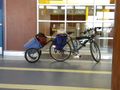
- Elbie, with a bike trailer containing, amazingly enough, a kayak.
The Plan
- 13:00 - ferry leaves Tsawwassen to Swartz Bay
- 15:00 - arrive at the public boat launch on Lands End Road, at the northern tip of the Saanich Peninsula
- hopefully 15:30 - get on the water
- hopefully 16:30 - get to the hashpoint
- 18:00 - start packing up kayak, head back to the ferry terminal
- 19:00 - ferry leaves Swartz Bay to Tsawwassen
Expedition
Abridged: I biked, I bussed, I ferried, I biked some more, then I kayaked, got there, paddled back, biked some more, ferried, bussed, and then biked home.
Proper writeup pending.
Photos
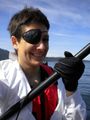
Yarr?
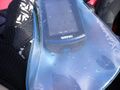
At the coordinates.
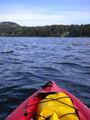
Heading back to land.
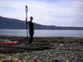
A Calendar Girl photo op while waiting for the kayak to dry.
Waited around Swartz Bay for three hours to get on a ferry.


Achievements
- Water
- Buccaneer
- Calendar Girl
- arguable: bike, public transit
- if Canada Post permits: hashcard