Difference between revisions of "2009-05-21 48 9"
imported>Ekorren (Not really a report.) |
imported>Ekorren (→Gallery) |
||
| Line 19: | Line 19: | ||
<gallery> | <gallery> | ||
| + | Image:2009-05-21_48_9_Gomadingen.jpg|Gomadingen station from a train driver's perspective | ||
| + | Image:2009-05-21_48_9_Muensingen_Bf.jpg|Historic class 796 railcar in non-historic livery at Münsingen | ||
| + | Image:2009-05-21_48_9_Barracks.1.jpg|Some abandoned barracks | ||
| + | Image:2009-05-21_48_9_WTF.jpg|wtf? | ||
| + | Image:2009-05-21_48_9_Snail.jpg|Finally some wildlife that didn't run away before I had the camera ready | ||
| + | Image:2009-05-21_48_9_Sternenbergturm.jpg|Built as a triangulation tower, used as a military observation tower later, now a viewtower | ||
| + | Image:2009-05-21_48_9_ForbiddenLand.jpg|View into forbidden land | ||
| + | Image:2009-05-21_48_9_Windmills.jpg|Modern windmills | ||
| + | Image:2009-05-21_48_9_GPS.jpg|Coordinates reached | ||
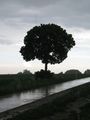
| + | Image:2009-05-21_48_9_HashTree.jpg|Hash Tree | ||
| + | Image:2009-05-21_48_9_Hashpoint.jpg|Hash Meadow | ||
| + | Image:2009-05-21_48_9_Forbidden.1.jpg|Mortal Danger! Absolutely forbidden to enter off marked ways. The entire area is contaminated with ammunition and other warfare agents | ||
| + | Image:2009-05-21_48_9_Forbidden.2.jpg|Forbidden track | ||
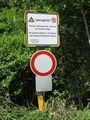
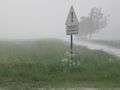
| + | Image:2009-05-21_48_9_Forbidden.3.jpg|Older, bilingual sign: German: "closed", French: "Forbidden area" | ||
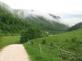
| + | Image:2009-05-21_48_9_Breithuelen.jpg|Old horse stables | ||
| + | Image:2009-05-21_48_9_Turm_B3.jpg|Military observation tower | ||
| + | Image:2009-05-21_48_9_Darrieus.jpg|Prototype windmill, didn't prove to be any good | ||
| + | Image:2009-05-21_48_9_Tree_BlackAndWhite.jpg|Black and white (see also [[Revisited]]) | ||
| + | Image:2009-05-21_48_9_Storm.jpg|Beware of ice droppings (well, the water was fluid, but there was too much of it in the air) | ||
| + | Image:2009-05-21_48_9_Valley_road.jpg|Down into the valley | ||
| + | Image:2009-05-21_48_9_Urach.jpg|Down in the valley | ||
</gallery> | </gallery> | ||
Revision as of 13:19, 22 May 2009
| Thu 21 May 2009 in 48,9: 48.4042194, 9.6254432 geohashing.info google osm bing/os kml crox |
Location
A remote meadow near Münsingen-Magolsheim
Expedition by Ekorren
So this was Geohashing Day. A day so much overloaded by expectations of "do your best expedition ever", "celebrate with everything you have" etc. that it could only not meet the expectations. And when the coordinates came out, they were totally disappointing. Nothing special, just a selection of remote fields and forests in reachable distance.
Ok, I chose a place. I reached it. It was one of my good expeditions. I took an historic train, explored an interesting area, found a triangulation tower, went through a beautiful landscape for hours, found shelter in the middle of nowhere when thunderstorms passed. Under normal circumstances I would probably gladly start writing now, telling you something about the Schwäbische Alb mountains, about the huge abandoned military training ground I circled. But it wasn't any exceptionally special expedition. There was nothing to really celebrate. And right now, I don't feel at all like writing it up. Maybe later. Sorry. Will post pictures soon, anyway.
Gallery
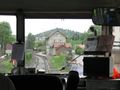
Gomadingen station from a train driver's perspective
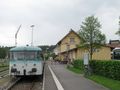
Historic class 796 railcar in non-historic livery at Münsingen
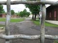
Some abandoned barracks
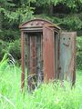
wtf?

Finally some wildlife that didn't run away before I had the camera ready
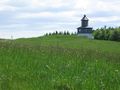
Built as a triangulation tower, used as a military observation tower later, now a viewtower
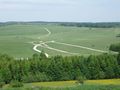
View into forbidden land
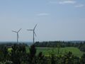
Modern windmills
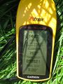
Coordinates reached
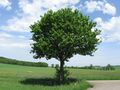
Hash Tree
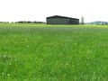
Hash Meadow
Mortal Danger! Absolutely forbidden to enter off marked ways. The entire area is contaminated with ammunition and other warfare agents
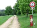
Forbidden track
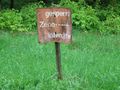
Older, bilingual sign: German: "closed", French: "Forbidden area"
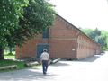
Old horse stables
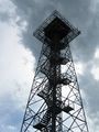
Military observation tower
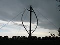
Prototype windmill, didn't prove to be any good
Black and white (see also Revisited)
Beware of ice droppings (well, the water was fluid, but there was too much of it in the air)
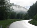
Down into the valley
Down in the valley


